My son and I have a Garmin inReach Explorer+ and a Garmin inReach Mini and I recently shared a route I had created with him but it didn’t work out as well as expected, so I decided to test it out again before hitting a new trail.


Let me walk you through, step by step, how you can create a route, waypoints, export it and then import it to another account and have it show up perfectly.
Garmin Earthmate Route & Waypoint Creation
My first step when I get ready for a hike is to research the trail on AllTrail. This is a great resource that seems to have every trail around and has the information I need to help me decide on my next adventure.

The next step is to go to your inReach page at www.inreach.garmin.com and select the Map tab at the top of the page and find your trail location.

Step 1: Create a Collection – I always name this the trail name.

Select the “+” to the right of Collections to create it and then give it a name. You can add a route and waypoints to the collection at this time if you already have it but as we don’t, we will add them later.
Make sure you share your MapShare page and sync to you Garmin device.
After you create the collection, you’ll need to create the route. Select the route at the top of the page and begin placing the points along the trail.

After you reach the end of your trail, you select the last point laid down to end the route. At this time, you can name the route and change the color.

This trail is rated as easy, so I have chosen green for the route color.
The next step is to create waypoints. I always start with the trailhead waypoint and you have the option to give it a name and chose the best waypoint.

I always select the hiker icon for each trailhead.

Once you create the route and waypoints, you will need to sync the Explorer map with the Earthmate app. We still need to add a few more waypoints so I will sync the inReach and Garmin after I am finished.

I will be adding two restaurants and a kayak rental location to this collection.

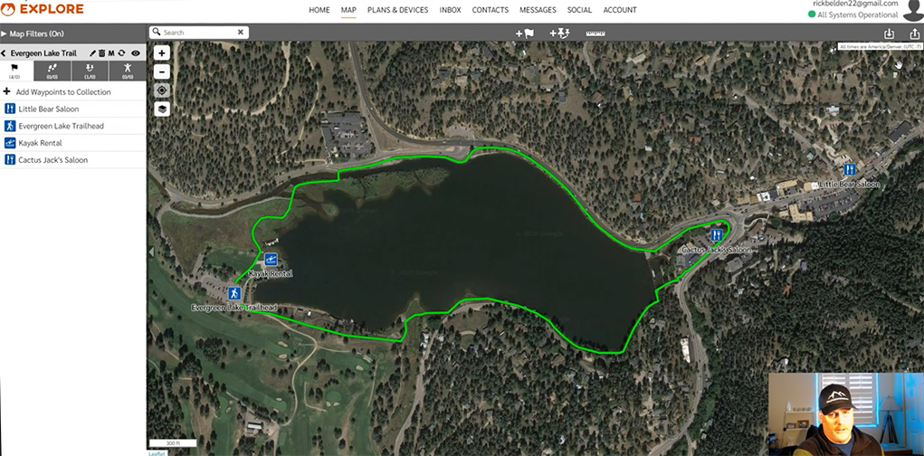
You can see in this next photo that completed route and waypoints.

Now it’s time to export the collection but before you do this, you should use the filter to show only the trail you want to export. You should turn off all the trails and waypoints as well. If you don’t do this, hundreds of points will be exported and will cause import and display problems with other users.

Another thing you can do is to zoom out and see if any other routes or waypoints are visible, prior to exporting the collection.
Next, select the box with the up arrow in the top right corner to begin the export process.

Select where you want the exported file to be placed, and it’s just that easy. Now, let’s look at the Import process.
Garmin Route Import
Importing the Garmin route is easier but there are still a few things you need to pay attention to.
First, select the box with the down arrow in the top right corner.

Next, import lines as routes.

Select Import Items as New Collections.

Select MapShare, then select your Garmin device to sync and finally give the import file a name.

Go ahead and find your GPX file and drag it into the box.

This next area is where you will want to verify what is being imported. I knew that I should only have one route and 4 waypoints but you can see below that there are 5 waypoints. One extra waypoint is okay to me because that is easy to find and delete but if you had 7 routes and hundreds of waypoints then you would want to close the box and start again.

You can see in the next slide that the route and waypoints came in correctly but the route color is red and the waypoint icons are blue flags, but these are all easy to correct.

You can see below an example of how to change a waypoint icon.

This next slide shows the completed edits of the route and waypoints.

Once this import is competed you will need to sync your Earthmate app to ensure the Garmin is updated with this data.
After this is complete, you will be ready to hit the trail.
You can see a short video of this route and waypoint creation below.
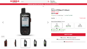
Check the information below to learn more about the Garmin inReach Explorer+ and the Garmin inReach Mini.

- Small, rugged, lightweight satellite communicator enables 2 way text messaging using the 100 percentage global Iridium network (satellite subscription required).Special Feature:Bluetooth.
- Trigger an interactive SOS to the 24/7 search and rescue monitoring center (satellite subscription required). Display size-0.9 x 0.9 inch
- Access downloadable maps, U.S. NOAA charts, color aerial imagery and more by using the free Garmin Earthmate app and compatible devices
- Optional inReach weather forecast service provides detailed updates directly to your inReach Mini or paired device, basic and premium weather packages available
- Send and receive inReach messages through compatible Garmin devices, including connected wearables and handhelds. Display resolution: 128 x 128 pixels
- NOTICE: Some jurisdictions regulate or prohibit the use of satellite communications devices. It is the responsibility of the user to know and follow all applicable laws in the jurisdictions where the device is intended to be used
This product was presentation was made with AAWP plugin.
I would like to hear your thoughts on the Garmin inReach features. Please leave a Comment Below or send me an Email.
Return to Home Page
![]()
I have never gone hiking or any adrenaline-accelerator trips. It’s amazing how far technology has taken us. I’m wondering though, are there any exact and verified alternative locations that you can take if the trail that you’re going through, for some reason, seems to be suspicious or if you’d rather go a different direction than what you already have planned. What if you get lost, is there an option to get some backup?
The nice thing about the Garmin products is that you can see the topo maps and they are connected to satellites so you will always have reception. If your trail is blocked or you need to find an alternative route, you will be fine if you study the maps and look for another route, but if you’re in real trouble, you can message people for help or use the S.O.S. button if you’re in a life-threatening situation.
Rick
The Garmin Earthmate device is such a useful tool to have and if it is used wisely, it can help in emergency situations I think. Such devices were not available in the old days for my wanderings, but I sure wish they had been. If some kind of emergency arises, at least people will know the path or routes that you planned and can easier track where you might be.
The steps that you included regarding setting up the routes then exporting and importing them was easy to understand and follow along with, and I came away feeling confident that this device is a super investment that anyone that is out and about in the wilderness should be using.
I am not sure how many of my friends know about this device so I am sharing your article and guide. There was no price listed but I imagine it is not that expensive? Really cost is not a consideration for me, rather it is the convenience and safety aspects that have sold me (and the ease of use). Thanks a bunch for this guide and tip!
The Garmin inReach Explorer+ can run $400 or more and the Garmin inReach Mini is around $300 or so. It all depends on what kind of sales are running but this is an inexpensive way to call for help if you ever need it.
Rick