Join me in this Garmin Fenix hiking field test.
Last month I bought the Garmin Fenix 7X Sapphire Solar and was immediately overwhelmed by how much it could do, so I’m breaking it down into shorter field tests so I can really test it and keep the videos from being to long.

First, let’s list some oft the features the Fenix Sapphire Solar offers for hiking.
Fenix Sapphire Hiking Features
- Navigation with Explore Routes
- Waypoint Creation
- Navigation by Waypoint
- Obvious Graphics for Following a Trail
- TracBack if Lost
- Back to Start
- Off-Course/On-Course Visual and Audible Alerts
- Vertical Speed
- Elevation Profile
- Pre-Loaded Topo Maps
- And Much More. See the Specifications List Below.

Fenix Hiking Field Test Results
Navigation by Route
First, I wanted to see how well the Fenix Sapphire watch navigated by route. I set up the route at home on my Garmin Explore site before heading out to the field. If you want learn more about setting up a route, you can check out the article on my website or YouTube channel below.
Website Article: https://hikingemergencybeacon.com/garmin-earthmate-export-import-route/
YouTube Video: https://youtu.be/UlPvu8RPz5w
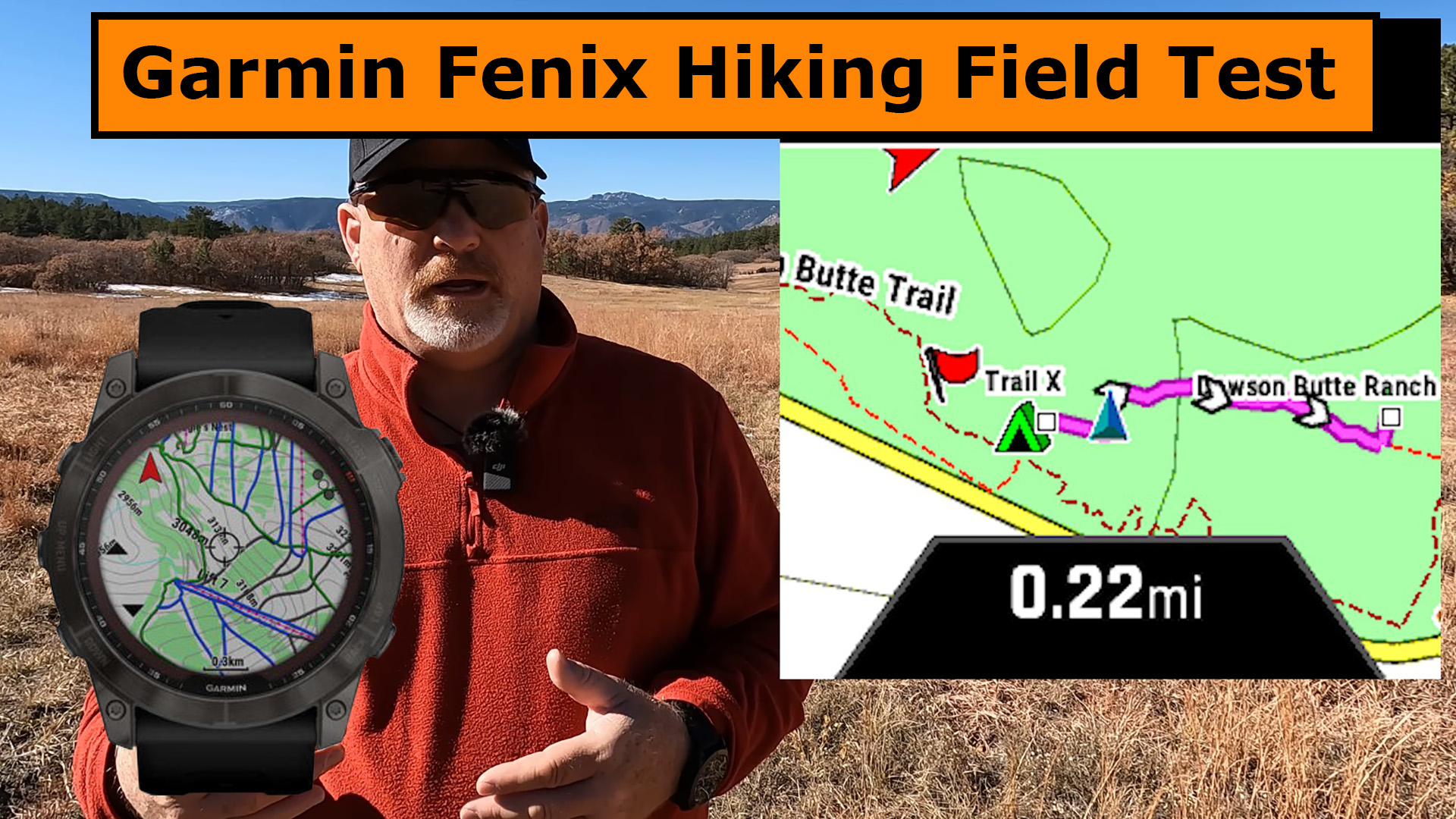
Navigating by route with the Fenix was great. It was easy to see the information on the screen and the trail shows up as a thick magenta line with arrows point in the correct direction. You can also choose to hike the route in the reversed direction. See some of the images below.

I wasn’t able to get screen shots of the Off and On Trail visual and audible alerts but I did get one photo taken from the video that you can barely make out the visual alert.

There is also a lot of great information you can see on the watch as you’re hiking, such as a profile of the trail, ETA, Vertical Ascent and much more. Checkout the photo below of some of the information you can see while hiking.

TracBack to Start
After hiking about 1/2 mile, I stopped navigating and acted like as was lost. I chose TracBack to Start and was impressed with the graphics shown on the Fenix watch and how accurately it showed my trail back to where I started hiking. Check out some of the images below.

Again, the TracBack worked perfectly and alerted me when I was Off-Course and when I started heading back On-Course. It gives a visual and audible alert.
Navigate to New Waypoint
My last test was to select a new waypoint, back to near the beginning of the hike but off to the side where I record a lot of my videos. It was simple to obvious how to set the waypoint, plus rename it and add an icon for it. Check out some of the screenshots below. These images are of a different waypoint I set but is the same procedure.

I was then able to navigate to my new waypoint which was half the distance to hike versus if I had followed my original path. You can see more of the screen shots of my return hike when navigating to the new waypoint.

Final Thoughts
There are several more things the Garmin Fenix 7X Sapphire Solar watch will do, but these are what I chose to test in this Field Test and are the primary functions I would use, which I believe is similar to what most people would be interested.
I was really impressed with the Garmin Fenix and I would highly recommend it to anyone, however, it is a luxury item and is not necessary to have a safe outdoor adventure.
I would strongly recommend taking a satellite messenger along with you on an outdoor adventure as the Fenix cannot call for Search and Rescue or message family and friends if you find yourself in trouble.
Check out the YouTube video below of the Field Test.

- Large 3 inch Sunlight-readable color display for easy viewing
- Trigger an interactive SOS to the geos 24/7 search and rescue monitoring center, two-way messaging via the 100% Global Iridium satellite network (satellite subscription required)
- Preloaded Garmin TOPO mapping with direct-to-device Birdseye satellite imagery downloads (no annual subscription), includes multiple global navigation satellite systems (GNSS) support and navigation sensors
- Cellular connectivity lets you access active weather forecasts and geocaching live
- Compatible with the Garmin explore website and app to help you manage waypoints, routes, activities and collections, use tracks and review trip data from the field
- Internal, rechargeable lithium battery provides up to 35 hours of battery life in 10-minute tracking mode and 1-minute tracking mode (display off), 200 hours in Expedition mode with 30-minute tracking
This product was presentation was made with AAWP plugin.

- Compatible with multiple Oregon, Alpha, inReach, GPSMAP, and eTrex devices.
- Durable nylon harness wrap
- 2-Inch - 14-Inch adjustable strap
This product was presentation was made with AAWP plugin.
Return to Home Page
![]()