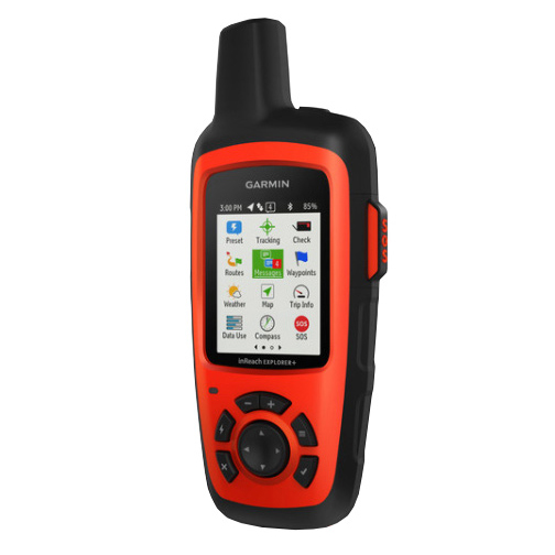
Garmin inReach Explorer+
- Send and receive text messages

- Setup predetermined messages
- Creates messages on the device but does not have a keyboard
- The only model that serves as a handheld GPS navigator with built-in topo maps
- Built-in altimeter
- Built-in barometer
- Built-in accelerometer
- Request weather updates
- Larger and heavier
- IPX7 – Waterproof
- Size = 6.5″ x 2.7″ x 1.5″
- Weight = 7.5 oz.
- Pro’s
- Easy 2-way messaging
- Great smartphone app
- Loaded and proven global network
- Con’s
- Expensive initial purchase
- Heaviest of the satellite messengers
You may venture off the grid, but you can still stay in touch, as long as you’re carrying an inReach Explorer+. This handheld satellite communicator is designed for the outdoor enthusiast who wants to roam farther and experience more, without compromising their loved ones‘ peace of mind. From backcountry experiences to international adventures, inReach provides communication, location sharing, navigation and critical SOS functions for anyone who loves getting away from it all, on land, water or in the skies.
No products found.
If you would like additional information or to see other models, go to my REVIEW PAGE, leave a COMMENT BELOW or send me an EMAIL.
Return to Home Page
SPECIFICATIONS
General | |
| Physical dimensions | 2.7″ x 6.5″ x 1.5″ (6.8 x 16.4 x 3.8 cm) with keypad and SOS door bump |
|---|---|
| Display size | 1.4″W x 1.9″H (3.5 x 4.7 cm); 2.31″ diag (5.9 cm) |
| Display resolution | 200 x 265 pixels |
| Display type | transflective color TFT |
| Weight | 7.5 oz (213.0 g) |
| Battery | Rechargeable internal lithium ion |
| Battery life | Up to 100 hours at 10-minute tracking mode (default); up to 75 hours at 10-minute tracking with 1-second logging; up to 30 days at the 30-minute interval power save mode; and up to 3 years when powered off |
| Water rating | IPX7 |
| Memory/History | 2 GB |
| High-sensitivity receiver | |
| Interface | USB |
Maps & Memory | |
| Preloaded maps | yes. The North America SKU of the inReach Explorer+ comes preloaded with a 1:24k map of Garmin Yarmouth (Former DeLorme) North America data of the U.S. and Canada. Mexico also is included at a 1:125k scale (derived from Garmin Yarmouth’s Digital Atlas of the Earth). |
|---|---|
| Ability to add maps | |
| Waypoints/favorites/locations | 500 |
| Routes | 20 |
Sensors | |
| Barometric altimeter | |
|---|---|
| Compass | Yes (tilt-compensated 3-axis) |
Outdoor Recreation Features | |
| Camera | no |
|---|---|
Additional | |
| Additional |
|
|---|---|
Garmin inReach Explorer
4.7
Pros
- 2-Way Messaging
- Built-In Navigation
- Pre-Downloaded TOPO Maps
- Global Satellite Coverage
- Long Battery Life
Cons
- Size & Weight
- Initial Purchase Price
Wow, one can also request weather forecast with the Garmin inreach explorer+? That’s very good. For anyone who goes far off the grid like you say it’s a perfect choice. I don’t like wandering but I think this will still be a good pick for me. With its wide enough display and fairly good battery, one can be rest assured to be connected to the outside world. Good review here.
This would be a great option for a lot of people. It does have a longer battery life and the nice thing is you can use it for other things than going off grid on a hike. Some people use it when they fly or go on a long road trip in the mountains. There are some people who live in hurricane prone areas and need a way to be able to communicate or SOS in an emergency when all of the cell towers are down.
Thank you for stopping by and sharing your thoughts.
Rick
This looks like a very useful device if you’re going into remote areas. Most everyone has had an experience where their cell phone was out of range and needed to connect with someone or needed to send a message for help. This unit looks like a very powerful solution. Is there a ongoing connection or service a person would have to subscribe to?
Yes, you need a subscription to have access to these functions. Here are is a list below of the subscriptions available:
Safety: $11.95/month (annual contract); $14.95 monthly only
Recreation: $24.95/month (annual contract); $34.95 monthly only
Expedition: $49.95/month (annual contract); $64.95 monthly only
Extreme: $79.95/month (annual contract): $99.95 monthly only
As you can see, there are many options to choose from and Garmin helps walk you what is the right one for you.
I hope this helps. Let me know if you have any more questions.
Rick
This seems like the perfect addition to any hikers accessories. It seems to have everything you would want like weather updates, text messaging and even built in apps. I didn’t realize they had such great gadgets available for the avid hiker.
I was blown away by the battery life and of course you really can’t go wrong with anything Garmin. They really make the best products.
This is a great post. Also I wanted to say that I really like your website design. It is very clean and airy. Great job.
Thank you so much for the comments and compliments.
It is impressive what is now being offered with these satellite messengers and for the price. I was looking at satellite phones a while back and I had to stop looking because I just couldn’t afford them. But now, these satellite messengers have the SOS function, 2-way messaging, weather forecasts and more and for a really reasonable price. I really am impressed.
Thank you for stopping by and sharing this with me.
Rick
I must say this is one very important post. I am a cameraman for a documentary channel and sometimes we go to the desert for filming and this makes my wife a lot anxious because she finds it hard to reach me because of the bad service. I am glad to have come across this post and would make sure I get this device for myself for the situation on ground. Thanks for sharing.
Thanks for sharing this Dane. I started this site off with a focus on hiking but it is amazing to hear of all the different uses that the Garmin inReach Explorer+ has. You can be in a hard to reach location or you may be in a local disaster, such as a hurricane and need to reach someone when the cell towers are all down.
Thanks for stopping by and let me know how you like using the Explorer+ the next time you are on location.
Rick
Hello! I just read your article on the Garmin inReach Explorer+. This device seems amazing. I love that it always tracks your coordinates, etc. JUST IN CASE of an emergency. I do have a question… does this work more as like a HAM radio OR more like a cell phone? I believe you mentioned it running off of a satellite. Does this mean that you do not have to utilize cell phone data or wifi in order for this product to work? Also the battery life on this device sounds amazing. I will definitely be looking into this product. Thank you!
Ham radios work off many frequencies in the radio spectrum so it is different that how the Garmin inReach Explorer+ works off satellites. It does not operate as a cell phone or use wifi. It sends and receives messages via the global Iridium satellite network. You can send messages to anyone with a cell phone number or email and you can also post to social media.
This truly is a powerful satellite messenger and it has the built-in navigation too. This is one that I have added to my birthday wish list.
I hope this helps,
Rick
Excellent review about Garmin inReach Explorer+. I personally like Garmin products, and when it comes to the Explore+, that’s going to be amazing as usual I know. You explain every feature of this product very well. As I saw the price is a bit high but compared if its features and advantages, it’s not going to problem think. Someone from my son’s college was talking about this device last week, I am going to share this review with him, I think he will get help. Thanks a lot for this great review.
The initial price for the Garmin inReach Explore+ is high but having the navigation built into the satellite messenger and then having the option to send and receive messages would be invaluable.
I don’t like being bothered when out on a hike but when an emergency arises, those 2-way messages would be great to have. How many times do we find ourselves in non-life-threatening emergencies but we are still in trouble. The price will be worth it when that happens.
I realized yesterday, on a long 12 mile hike, that I would have really liked to have the built-in navigation with me. I will be adding this to my list to buy soon.
Rick
Thanks for this informative article, It does a very good job of predicting the next word which speed up things. Transmit and receiving speeds are good, but my curiosity is why it doesn’t work indoors? I noticed it needs to be outside with a view of the sky before it works effectively, Great product. I depended on it during a hurricane. Subscription pricing is fair as well.
Thanks for sharing how you used it during a hurricane. This just goes to show that these can be used in many more situations than just an adventure in the outdoors.
The emergency rescue beacons, called PLBs or Satellite Messengers, get their information from a network of satellites and must have a clear view of the skies.
Whether you are in a building needing to be rescued or in a deep ravine in the mountains, you may need to find a clear view of the sky to get the signal out or have the signal be located by rescue teams.
Rick
Thanks for the details about the Garmin inReach Explorer+. Are these used by rescue search teams and public servants?
I am a career firefighter in the midwest and we use GPS in our mobile data terminals for tracking available equipment and mapping to find the address for our runs.
What is the primary use for this device for search teams?
I love great questions and you have hit on a good one. The Garmin inReach Explorer+ uses the global Iridium satellite network and when the SOS is activated, the message is sent out to a rescue monitoring center. The messages are sent to GEOS, located in Houston, Texas. They in turn, send out rescue alerts to SAR agencies around the world.
I cannot answer your question completely as I am not aware of the tracking tools that search and rescue teams use to locate a signal coming from a locator beacon, such as the Explorer+. On that note, I will be learning more about it as my daughter has joined the mountain search rescue team in Gunnision, Colorado so this will be on the top of my list to learn from her.
Search teams will be using the signal being sent from Garmin inReach Explorer+ to track and help locate the person. I am not sure if the search teams are using emergency locator beacons themselves but it would be smart as they are breaking off into groups to search the area and an emergency beacon would be wise to have on each of the team members. I will be finding out more about this also with how the Gunnison Mountain Search and Rescue team operates.
I hope this helps some. I know I did not answer your question specifically but I will be learning more about this soon. I would love to hear more from you about how your team conducts a search and what equipment is used to locate a signal from an emergency locator beacon.
Rick
Hello 🙂
You have such a great site!
The Garmin inReach Explorer+ sounds amazing. It looks like the perfect gadget for any terrain, and I love all it’s extra features, especially the two-way messaging. The weather forecasts and all the extras also make it a great buy in my opinion.
For what type of hike would you recommend this specific device?
Thanks for the great article.
Before yesterday’s 12 mile hike, I would have told you the Garmin inReach Explorer+ would be great for longer, more remote hikes but that is not true at all.
I was hiking just north of Colorado Springs yesterday and the map said it was a 9.3 mile loop around Mount Herman but I felt like and other GPS information said that I may have gone over 11 miles. That may be because I took little detours to check things out.
The bottom line for me is when I was on the backside of Mount Herman (west side), I lost cell coverage and there were many times trails took off in different locations and they were definitely not on the map, plus when I lost cell service, I couldn’t get the same information I was enjoying earlier. I was thinking the Garmin inReach Explorer+ may be on my birthday wish list now.
I think it just depends on if you like using a built in navigation in your satellite messenger. If the answer is yes, than it will be nice to have anywhere.
I hope that helps,
Rick