What Garmin inReach Subscription Plan should I get? Should I get the Monthly Plan or Annual Plan?


How do I know if the Recreation plan in better than the Safety Plan or the Expedition Plan?
Monthly or Annual Subscription Plan?
Here’s what Garmin recommends when you’re considering a monthly or annual plan.

Personally, I would go a little farther with my advice.
If you will use your Garmin inReach satellite messenger up to 8 months, then it will still be less expensive then the annual plans.
However, I would absolutely recommend the monthly plan if you only go out in the summer, hunting season, ski season, etc.
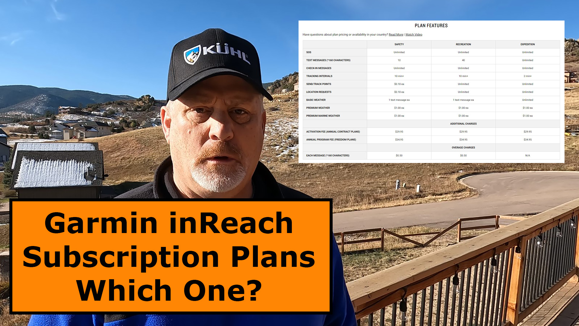
Safety, Recreation or Expedition Plan?
Here are the plan features from Garmin.

For the majority of Garmin satellite messenger users, I would recommend the Recreation Plan. You will get up to 40 free messages and unlimited tracking points and location requests.
If you only want to use your satellite messenger in emergencies then the Safety Plan may be the right one for you.
If you like to message a lot or want greater detail on tracking intervals, then I would recommend you consider the Expedition Plan.

Safety Plan Subscription

Recreation Plan Subscription

Expedition Plan Subscription

Final Thoughts
For most users, the monthly recreation plan is my recommendation.
Please leave a comment below if you have any additional questions and check out the short YouTube video below.

- Small, rugged, lightweight satellite communicator enables two-way text messaging even in areas with no cell coverage (Active satellite subscription required. Some jurisdictions regulate or prohibit the use of satellite communication devices)
- Send two-way messages globally; easily text back and forth directly with friends via the Garmin Messenger app, even when you’re out of cellular coverage. (Active satellite subscription required. Some jurisdictions regulate or prohibit the use of satellite communication devices.)
- Group messaging via the Garmin Messenger smartphone app lets you share your adventures with multiple contacts simultaneously — and have group text chats with friends and family
- Check in with contacts directly by using preset messages that do not count toward your allotted text messages (Active satellite subscription required. Some jurisdictions regulate or prohibit the use of satellite communication devices)
- Share your GPS location (Active satellite subscription required. Some jurisdictions regulate or prohibit the use of satellite communication devices)
- Trigger an interactive SOS to the Garmin IERCC 24/7-staffed monitoring and coordination center for help in an emergency (Active satellite subscription required. Some jurisdictions regulate or prohibit the use of satellite communication devices)
This product was presentation was made with AAWP plugin.

- Compact, lightweight satellite communicator enables two-way messaging and interactive SOS globally (Active satellite subscription required. Some jurisdictions regulate or prohibit the use of satellite communication devices.).Special Feature:Bluetooth.Water Resistant: Yes
- Navigate back to where you started by using TracBack routing
- Share your location with loved ones back home at any time (active satellite subscription required) by using your MapShare page or with your coordinates embedded in your messages
- Get accurate heading information using the digital compass — even when you’re not moving
- Sync with the Garmin Explore app and website on your compatible smartphone for trip planning and topographical mapping, and create waypoints, courses, activities and collections you can sync to your device
- Pair with Garmin devices, such as wearables and handhelds, and use them to send and receive messages and trigger an SOS (active satellite subscription required)
This product was presentation was made with AAWP plugin.

- Large 3 inch Sunlight-readable color display for easy viewing
- Trigger an interactive SOS to the geos 24/7 search and rescue monitoring center, two-way messaging via the 100% Global Iridium satellite network (satellite subscription required)
- Preloaded Garmin TOPO mapping with direct-to-device Birdseye satellite imagery downloads (no annual subscription), includes multiple global navigation satellite systems (GNSS) support and navigation sensors
- Cellular connectivity lets you access active weather forecasts and geocaching live
- Compatible with the Garmin explore website and app to help you manage waypoints, routes, activities and collections, use tracks and review trip data from the field
- Internal, rechargeable lithium battery provides up to 35 hours of battery life in 10-minute tracking mode and 1-minute tracking mode (display off), 200 hours in Expedition mode with 30-minute tracking
This product was presentation was made with AAWP plugin.

- Features rugged military-grade construction and a 5” touchscreen display that’s 50% larger than the previous model; offers easy viewability and includes versatile mounting solutions.Control Method:Touch,Application.Special Feature:Routable Topo Maps; Multiple GNSS Networks, ABC Sensors; inReach Satellite Communication; BirdsEye Satellite Imagery.
- Trigger an interactive SOS to the GEOS 24/7 monitoring center — two-way messaging via the 100% global Iridium satellite network (active satellite subscription required; some jurisdictions regulate or prohibit the use of satellite communications devices).
- Multi-GNSS (GPS and Galileo) support — plus preloaded TopoActive maps and City Navigator street map navigation; navigation sensors include 3-axis compass and barometric altimeter
- Pro-connected with ANT+ technology, Wi-Fi connectivity and BLUETOOTH wireless networking, giving you direct-to-device access to BirdsEye Satellite Imagery downloads, location sharing, Connect IQ app support and more
- Compatible with the Garmin Explore website and app to help you manage waypoints, routes, activities and collections, use tracks and review trip data from the field
This product was presentation was made with AAWP plugin.
Return to Home Page
![]()