Here’s a FIRST LOOK at the Garmin GPSMAP 67i Review & Field Test. I’m going over most everything the GPSMAP 67i will do, but will follow up with a 67i training list over the next several weeks and months.

Garmin GPSMAP 67i Features
- With inReach Technology
- Two-Way Messaging
- Interactive SOS Alerts

- Location Sharing with MapShare
- Longer Battery Life Over the 66i
- Up to 165 Hours in Tracking Mode
- Up to 425 Hours in Expedition Mode
- Track Your Position with Multi-Band Technology
- Expanded GNSS Support
- Get Access to Multiple Frequencies to Improve Positioning Accuracy
- ABC Sensors
- Altimeter
- Barometer
- 3-Axis Electronic Compass
- Download High-Resolution, Photorealistic Maps
- Pre-Loaded Maps of North America
- Outdoor Maps Subscription
- Access to Public Land Information
- Landowner Names
- Hunting Management Unit Boundaries
- BLM Boundaries
- 100% Global Iridium Satellite Network
- Garmin Messenger App
- The 67i Now Joins the Mini 2 with Access to the Messenger App
- Group Messaging
- Transitions between WIFI, Cell Service and Satellite Service, Automatically
- inReach Weather
- Active Weather
- Extensive Navigation Capacity
- Built to Military Standards for Thermal, Shock, and Water Performance
- Includes an LED Flashlight
- Get Automatic Cache Updates
inReach SOS Call Button
It’s simple to call for help in a life-threatening emergency, by opening the cover on the right side of the GPSMAP 67i and depressing the SOS button for about three seconds.

You can also schedule an SOS test with the IERCC that will give you greater confidence it will work when you need it most.
Two-way Messaging
I’m starting with SOS and 2-way messaging as these may be the most important aspects of the GPSMAP 67i when it comes to saving your life or someone you know.
There are several ways to messaging on the 67i.
- Check-in Messages (they don’t count as a message, so they are free)
- Quick Text Messages
- Two-way Messages
First the Check-in Messages. This is an easy message to initiate and it gives your location to whomever you shared it with, plus, it does not account for your messages if you have the Safety or Recreation plan.

Next, let’s look at the Quick Text Messages. You need to set these up on the Explore Garmin website before heading out on your adventure. This is where you can personalize the messages.

When you’re out on the trail, it will be much easier to use these Quick Texts, rather than typing it all out every time.

Next is the two-way messaging.
The first thing you need to do is select your contact or contacts, then you’ll see an area to type out your message.

Lastly, don’t forget about the Check-in Messages. You need to set them up first on your Explore.Garmin web page, then it’s really simple to select it and it automatically sends without you having to hit send.

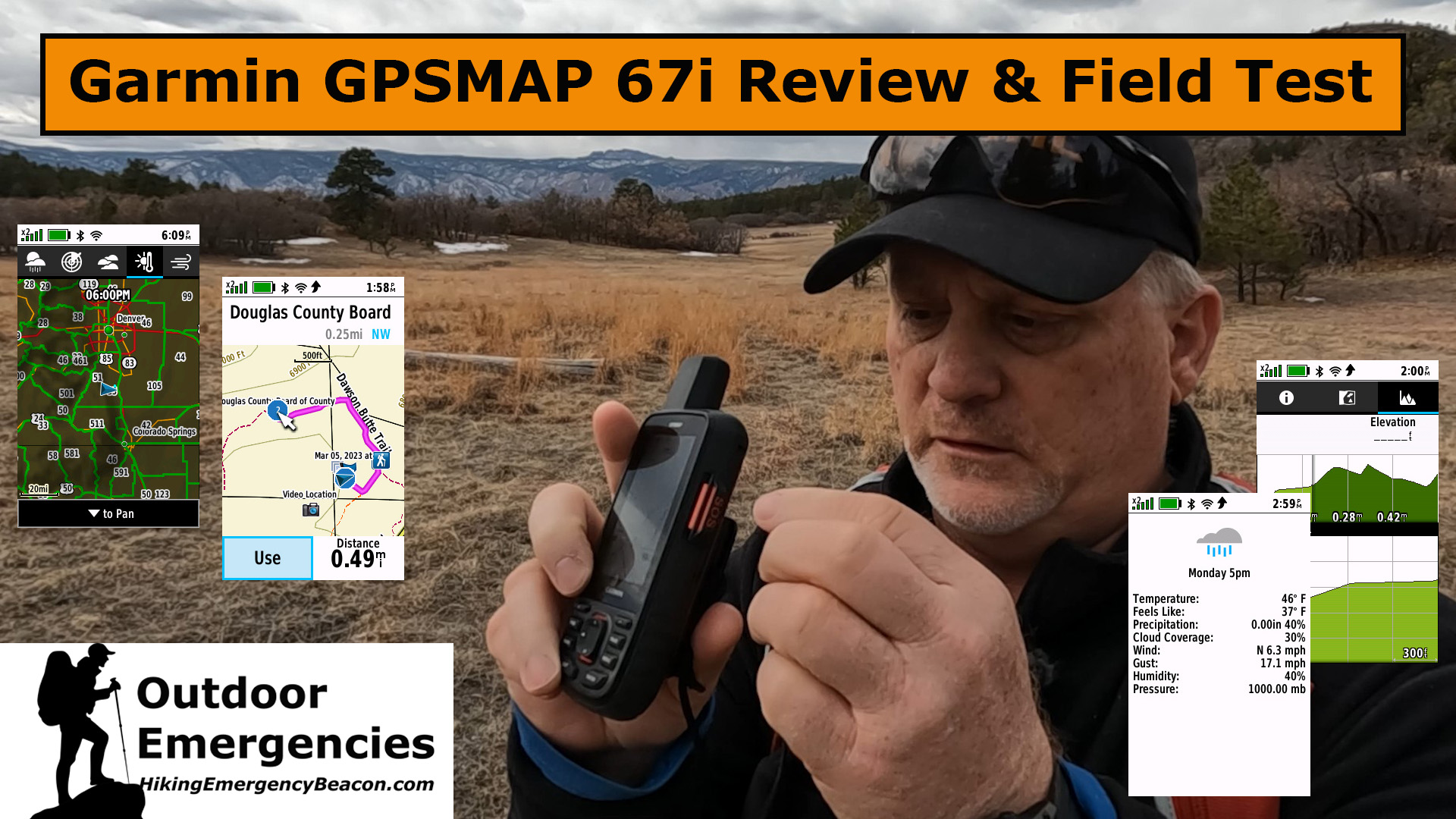
GPSMAP 67i Menus
The nice thing about the new 67i is that Garmin has less menu items in the default layout over what the 66i had. There are so many menu items that it can seem overwhelming at first glance.
However, there is a great feature under the menu settings where you can add, delete and move the menu items around so the ones you use are at the top of each menu you page. Here’s an example of how I re-arranged my menus.

You can completely customize your menus to make it much easier for you to get around in the new GPSMAP 67i.
inReach Tracking
Another valuable feature of the GPSMAP 67i is tracking and TracBack. Whether you tracked or not, you can TracBack to safety if you find yourself in trouble.
First, it’s always best to start tracking on any adventure. You will have valuable information at your fingertips if needed.

Second, the 67i starts recording your activities when you turn it on, so even if you didn’t start tracking, you would be able to TracBack if you go to RECORDING CONTROLS and select TracBack.

Lastly, the TracBack feature is always available and will help you get back to safety, plus it will alert you if you are ON COURSE or OFF COURSE.

GPSMAP 67i Navigation
The GPSMAP devices are great at navigating. Whether you created a route on the Explore Gamin site or you create it on your GPSMAP 67i, you’ll enjoy how easy it is to follow a course to your favorite destination.
One thing I always use to do was to create my hiking routes at home before heading to the trail. It’s easy to do and here is an example of one of my hikes.

Here is another course I created on the 67i by Direct Path.

Garmin has made it much easier to create courses and routes lately on the 67i device itself, or using your smartphone when synced to your GPSMAP 67i. It’s actually easier to create the course on your smartphone as you can use the touch screen and place your points by simply touching the screen. Here is a course I created during this field test.

It’s easy to follow your course as it’s magenta in front of you and cyan behind you. Lastly, if you find yourself lost, you can stop navigating and select TRACBACK to take you back to safety.
Garmin Maps
The maps that come pre-loaded on the 67i are incredible, but you can purchase an annual Outdoor Maps+ subscription that will give you access to many more maps, including public/private land boundaries, national forests, BLM land, city and state land, plus will show hunting units.

Weather Forecasts
It’s always great to have weather forecasts at your fingertips and the new GPSMAP 67i makes it even better with the Active Maps that allow you to see weather in more detail, including radar images. You will need cell service to access these more detailed weather maps.

But, if you’re outside cell service, you can still request BASIC and PREMIUM weather that will be available with the satellite service.

Final Thoughts
The Garmin GPSMAP 67i absolutely blows the 66i away, if only in the battery life improvement, however, it has several other things that is close to making it my favorite, go-to satellite communicator, and possibly replacing the inReach Mini 2 from the top spot.
Check out this in-depth review and field test of the new Garmin GPSMAP 67i.
No products found.
No products found.
No products found.
Return to Home Page
![]()
Thank you for your work on providing people information about the 67i. I just purchased my very first gps hand-held unit (67i) and figured out some stuff watching your videos on youtube, but get frustrated about some things I still am struggling with in operation. When can I get help? Because although youtube is great, some people either talk too fast on there, cover material too quickly, or are too vague and miss detail that is critical.
If you have a specific question, just message me about it and I’ll do my best to answer it, plus I may even make a video response to you, but you can always call Garmin and get a technician on the phone if you would prefer that.