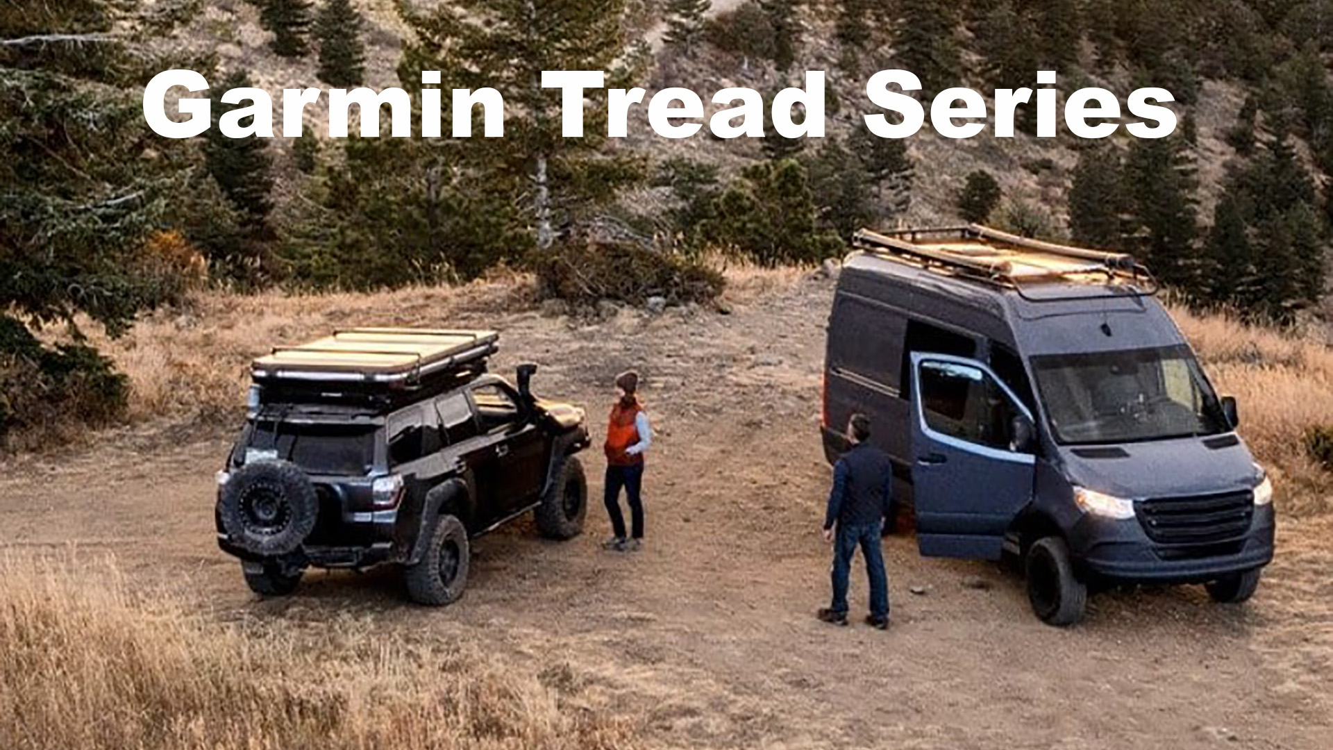
Garmin Tread Series for Off-Road navigation.
Garmin Tread Series
Here are a list of the Garmin Tread Series satellite communicators / navigators.
- Tread
- Tread – Base Edition
- Tread – SxS Edition
- Tread – Overland Edition
- Tread XL – Overland Edition
- Tread XL – Baja Race Edition [Race Vehicle]
- Tread XL – Baja Chase Edition [Chase Vehicle]
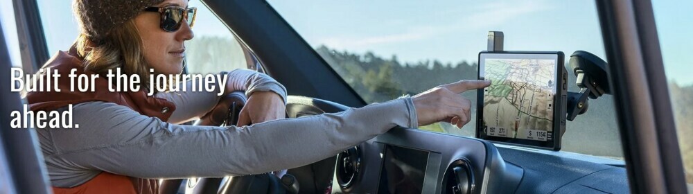
Built for every journey in your all-terrain vehicle with a primary focus on navigation and navigation to stay in touch on your rugged adventures.
It’s hard for me to tell you everything here that there is to know about these devices as they are specialized and built for an environment that I don’t currently operate in.
I have talked with Garmin Tech Support many times about these but have learned that it’s best for people who are interested in these to go directly to Garmin to get expert advice on what is best for their particular situation.
Check Out the Links Below to Learn More
- Rugged, weather-resistant (IPX7 water rating) powersport navigator with 5.5” glove-friendly and ultrabright touchscreen for off-road adventures
- Preloaded topographic maps of North and Central America, street maps of North America, U.S. public and private land boundaries, U.S. Forest Service roads and trails with Motor Vehicle Use Maps, and downloadable, subscription-free BirdsEye Satellite Imagery
- Powered mount and wiring harness secure the Tread navigator to your powersport vehicle
- Pair with a compatible inReach satellite communicator to stay in touch globally (sold separately; subscription required and subject to regulations or prohibitions in some jurisdictions)
- Use the Tread app to sync your waypoints, tracks and routes across devices, plus get easy GPX Import/Export and access to live weather when paired with your compatible smartphone using an active Wi-Fi connection
- Pairs with select Garmin GPS dog trackers (sold separately) to navigate and track your dogs from your vehicle
This product was presentation was made with AAWP plugin.
- IN THE BOX: 1x Garmin Tread Base Edition 5.5in Rugged Powersport Off-Road GPS Navigator; 1x Wearable4U Power Pack
- Purpose-built for all-terrain use, Tread stands up to anything the elements can throw at it. It’s IPX7-rated for water-resistance. With its ultrabright 5.5” glove-friendly touchscreen, the Tread navigator is designed for easy viewing in bright sunlight or pitch dark. It can be mounted in portrait or landscape mode.
- Tread features preloaded topographic maps of North and Central America and detailed street maps of North America. It also includes trail maps for full-sized 4x4s, side-by-side, ATVs and motorcycles. Download high-resolution BirdsEye Satellite Imagery directly via Wi-Fi connectivity, with no annual subscription required.
- Use the Tread app to sync waypoints, tracks, routes and collections across your devices, including your mobile device, computer and Tread navigator. Easily import and share GPX files, too. For tough-terrain guidance, built-in sensors include an altimeter, barometer, compass and pitch/roll gauges.
- WEARABLE4U ULTIMATE POWER PACK: Wearable4U USB Power Bank 2200 mAh, Wearable4U Car Charger, Wearable4U Wall USB Charging Adapter. Keep your device charged at all times with our Wearable4U Power Bank and the duo of the Wall & Car USB Charging Adapters!
This product was presentation was made with AAWP plugin.

- Rugged, weather-resistant powersport navigator with an 8” ultrabright, glove-friendly touchscreen; includes locking magnet-assisted mount and tube mount for securing to your vehicle. (IP67; Dust tight. Withstands ingress of dust with vacuum applied. Withstands incidental exposure to water of up to 1 meter for up to 30 minutes.)
- Stay connected to your friends with the Group Ride Radio featuring push-to-talk fist mic and group tracking for up to 20 riders. (Group tracking is available for riders using a Tread navigator, and only riders with a Tread navigator may be tracked. Connection to vehicle power is required for group tracking and push-to-talk mic functionality.)
- Turn-by-turn trail navigation for traversing unpaved roads and trails using adventure roads and trails map content. (Limitations may exist in map data for some road and trail route suggestions. Always defer to all posted road signs and conditions during vehicle operation. The Garmin OpenStreetMap products are intended to be used only as a supplementary travel aid and must not be used for any purpose requiring precise measurement of direction, distance, location or topography.)
- Comprised of OSM and USFS Motor Vehicle Use Maps, City Navigator road maps for custom street routing takes into account the size and weight of your vehicle. (Not available in all areas. Entering your vehicle’s profile characteristics does not guarantee your vehicle’s characteristics will be accounted for in all route suggestions. Always defer to all posted road signs and road conditions.)
- Preloaded topographic maps with 3D terrain of North and Central America, U.S. public and private landowner information and subscription-free BirdsEye Satellite Imagery via direct-to-device download
- Pair with the Tread app on your compatible smartphone to track friends using Group Ride Mobile feature, sync your trip data across all your devices and plan routes with the same maps, vehicle profiles and route preferences you have on the Tread device. (Tracking via Group Ride Mobile requires the Tread app running on your and each friend’s compatible smartphone with BLUETOOTH technology and an active cellular connection.)
This product was presentation was made with AAWP plugin.

- Rugged, weather-resistant (IP67; Dust tight. Withstands ingress of dust with vacuum applied. Withstands incidental exposure to water of up to 1 meter for up to 30 minutes.) all-terrain navigator with an 8” ultrabright display; includes locking magnet-assisted mount for securing in your rig
- Turn-by-turn trail navigation for unpaved roads and trails using adventure roads and trails map content (Limitations may exist in map data for some road and trail route suggestions. Always defer to all posted road signs and conditions during vehicle operation. The Garmin OpenStreetMap products are intended to be used only as a supplementary travel aid and must not be used for any purpose requiring precise measurement of direction, distance, location or topography.)
- Comprised of OSM, and USFS Motor Vehicle Use Maps; City Navigator road maps for custom street routing takes into account the size and weight of your rig. (Not available in all areas. Entering your vehicle’s profile characteristics does not guarantee your vehicle’s characteristics will be accounted for in all route suggestions. Always defer to all posted road signs and road conditions.)
- Preloaded topographic maps with 3D terrain of North and South America, U.S. public and private landowner information and subscription-free BirdsEye Satellite Imagery via direct-to-device download
- Built-in inReach technology offers global satellite communication, two-way text messaging, location sharing and interactive SOS. (Requires an active subscription. Some jurisdictions regulate or prohibit the use of satellite communications devices.)
- Preloaded with iOverlander points of interest and Ultimate Public Campgrounds, so you don’t need a cell signal to route to the best-established, wild and dispersed campsites
This product was presentation was made with AAWP plugin.

- This Bundle Contains: 1 Garmin Tread XL Overland, All-Terrain Navigator, Rugged, Built in Mapping, iOverlander, Ultrabright Display, Large + 1 Signature Series Microfiber Cloth
- Rugged, weather-resistant all-terrain navigator with 10” ultrabright display; includes locking magnet-assisted mount for securing in your rig. (IP67; Dust tight. Withstands ingress of dust with vacuum applied. Withstands incidental exposure to water of up to 1 meter for up to 30 minutes.)
- Turn-by-turn trail navigation for unpaved roads and trails using adventure roads and trails map content. (Limitations may exist in map data for some road and trail route suggestions. Always defer to all posted road signs and conditions during vehicle operation. The Garmin OpenStreetMap products are intended to be used only as a supplementary travel aid and must not be used for any purpose requiring precise measurement of direction, distance, location or topography.)
- Comprised of OSM and USFS Motor Vehicle Use Maps, City Navigator road maps for custom street routing take into account the size and weight of your rig. (Not available in all areas. Entering your vehicle’s profile characteristics does not guarantee your vehicle’s characteristics will be accounted for in all route suggestions. Always defer to all posted road signs and road conditions.)
- Preloaded topographic maps with 3D terrain of North and South America, U.S. public and private landowner information and subscription-free BirdsEye Satellite Imagery via direct-to-device download. Built-in inReach technology offers global satellite communication, two-way text messaging, location sharing and interactive SOS.
This product was presentation was made with AAWP plugin.

- Rugged, IP67 off-road racing navigator with a large 10” ultrabright touchscreen and included Tread XL Race Dock for easy, push-button controls
- Team tracking with built-in inReach technology (Requires active inReach Flex Team subscription. Some jurisdictions regulate or prohibit the use of satellite communications devices.) allows race vehicles and chase trucks to message and track each other with live position updates from anywhere
- Panel mount the device directly to the dashboard, or use the included bail mount to secure; external inReach device (Requires active inReach Flex Team subscription. Some jurisdictions regulate or prohibit the use of satellite communications devices.) and GPS antennas are included for optimal performance
- GPX course file-compatible to view course start/end, racetrack line, virtual checkpoints and race mile markers
- Prerunning tools to create custom pacenotes — such as “sharp turn,” “stepdown” or “danger” — helps anticipate obstacles and navigate your most efficient route through all virtual checkpoints
- Track recorder helps drivers record their performances and improve their race times by saving splits/laps
This product was presentation was made with AAWP plugin.

- Rugged, IP67 off-road chase navigator with a large 10” ultrabright touchscreen
- Team tracking with built-in inReach technology (Requires active inReach Flex Team subscription. Some jurisdictions regulate or prohibit the use of satellite communications devices.) allows race vehicles and chase trucks to see the live positions of your race team and message each other with global satellite coverage
- Secure inside your truck quickly and easily with a heavy-duty suction cup, CLA and portable locking magnet-assisted mount to move from one support truck to another
- GPX course file-compatible to view course start/end, racetrack line, virtual checkpoints, pit locations and race mile markers
- Prerunning tools create custom pacenotes — such as “sharp turn,” “stepdown” or “danger” — to help anticipate obstacles and navigate your most efficient route through all virtual checkpoints
- Chase mode lets you track your race vehicle with real-time updates on the map
This product was presentation was made with AAWP plugin.
Return to Home Page