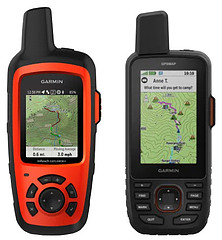
Let’s look at the Garmin Explorer Plus vs Garmin GPSMAP 67i and see what the differences are.
What Do They Have in Common?
- SOS Emergency Services
- Two-way Messaging
- inReach Technology
- Navigation
- Topo Maps & Aerial Maps
- Weather Forecasts
- Tracking
- MapShare
- TracBack
How Are They Different?
These both are Garmin inReach devices, and the GPSMAP 67i has a larger screen, faster processor, plus has additional menu items that can be re-arranged, added or removed.
Final Thoughts
The GPSMAP 67i seems to have replaced the Explorer+ and is much more powerful. Garmin will eventually stop supporting the Explorer+, and even now, Garmin does not sell it on their website. You can only get the Garmin Explorer+ on retail sites that still have stock available.
I recommend saving your money up to buy the more expensive 67i as it is a better device, plus the Explorer+ is being phased out.
Check out this YouTube video below for more information.
- 100 percent global Iridium satellite coverage enables two way text messaging from anywhere (satellite subscription required)
- Trigger an interactive SOS to the 24/7 search and rescue monitoring center
- Track and share your location with family and friends. Water rating : IPX7. Battery : Rechargeable internal lithium ion
- Pair with mobile devices using the free earthmate app for access to downloadable maps, U.S. NOAA charts, color aerial imagery and more
- In reach explorerplus device adds preloaded Delorme topo maps with onscreen GPS routing plus built in digital compass, barometric altimeter and accelerometer
This product was presentation was made with AAWP plugin.
- Large 3” sunlight-readable color display for easy viewing
- Enable two-way messaging and location tracking via the 100% global Iridium satellite network, and trigger an interactive SOS to Garmin Response℠, a 24/7 staffed emergency response coordination center (active subscription required; some jurisdictions regulate or prohibit the use of satellite communications devices)
- Access preloaded TopoActive mapping from Garmin, view satellite imagery, and navigate with multi-band GNSS support and sensors
- When paired with your compatible smartphone, you can access active weather forecasts and Geocaching Live
- Use with the Garmin Explore website or app on your compatible smartphone to help you plan trips and more
- Get access to a wide variety of premium mapping content delivered directly to your device via Wi-Fi technology with an Outdoor Maps+ subscription
This product was presentation was made with AAWP plugin.
- Compatible with multiple Oregon, Alpha, inReach, GPSMAP, and eTrex devices.
- Durable nylon harness wrap
- 2-Inch - 14-Inch adjustable strap
This product was presentation was made with AAWP plugin.
Return to Home Page


