
It’s time to look at an in-depth review with field tests of the powerful Garmin GPSMAP 66i review. I thought the Garmin GPSMAP 66i was going to be my new favorite satellite messenger, but that may not be the case. Stay tuned to for my Final Thoughts at the end of the article to find out if the 66i made it to my top spot.


Garmin GPSMAP 66i Features
- SOS Transmission plus Interactive Communication with the Rescue Team
- 2-Way Messaging
- Location Sharing with Family and Friends
- Detailed Topo Maps (Without a Subscription)
- Pre-Loaded TopoActive Maps of the U.S. and Canada
- InReach Weather Forecasts
- Active Weather
- Up to 35 Hours of Battery Life
- Global – Pole to Pole Satellite Coverage
- Navigate with ABC Sensors
- Photo Realistic Maps (Without a Subscription)
- Wikiloc Trails
- Garmin Explore App
- More Features than I Have Ever Seen on a Satellite Messenger
SOS Transmission
For me, one of the top things I want a satellite messenger for is to communicate with others, especially in a life-threatening emergency. Having this powerful tool at my disposal helps to put me and my family at ease when I’m off on a Rocky Mountain adventure.

Another great thing about the 66i is that you can communicate with the rescue team to let them know the exact nature and severity of your injuries so they can understand how better to respond to you. They may need more advanced life support personnel or possibly even a medical helicopter extraction, or it may only be basic life support. The more you can communicate, the better chance you have for a quick and positive outcome to your rescue.
2-Way Messaging
When I started reviewing satellite messengers in 2019, I was under the false impression that I would never need or want a 2-way messenger. I thought a 1-way satellite messenger, such as the SPOT Gen 4, would be all I wanted, and being able to send a message or a track once in a while would be plenty.
I quickly learned that I really liked seeing my location on a topo map, plus communicating with friends and family at home and also others on my hiking team would become extremely important. There have been several times recently where this 2-way messaging became really important.

I originally thought my family would bother me too often when I was out on an outdoor adventure, with the 2-way messaging, however, that has not happened, so take a closer look at the two-way messaging and decide if you believe it will be important to you.
Location Sharing
Location sharing is extremely important, at least to me, and is only second to the SOS function. It really helps my family feel more at ease when they know where I am in the mountains, and honestly, it helps me relax more knowing they would know where to start a search if I did not return home.
The other thing that became really important in my last two fishing trips in Colorado with my Buddy Mike, from MikenRickOutdoors, was that we both needed our Garmin satellite messengers to find each other in the Colorado Rocky Mountains, in order to find the camp site, or find each other on the river, as we often split up once or twice during the day. The location sharing is great for friends and family that are back home, or for you adventure buddies with you in the mountains.

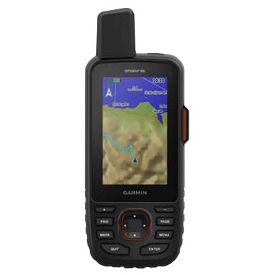
Detailed Topo Maps
What can I say, having topo maps on your satellite messenger may not be important to you, but after hundreds of outdoor adventures in Colorado, it has become important to me.
One issue is that many times a trail will not show up on any map, but when you have a route created or a trail that shows up on your Garmin GPSMAP 66i, and all of a sudden an unknown trail shows up on your hike, you can easily figure you which direction you should go.
Granted, having a physical map with you is always a good idea in case you lose satellite service or power on your satellite messenger, but it’s great having the convenience of looking at your satellite messenger and be able to find your self on a topo map. It’s not important to some people, but I have found I appreciate having the maps, possibly more then having any other function on my satellite messengers.

InReach Weather Forecasts
Having access to weather forecasts can be important, but honestly, I have not found this to be of great concern for me. Yes, it’s nice to know if a particular day ahead is going to be sunny or rainy, but anyone who visits Colorado much, understands that afternoon thunderstorms are just a way of life around here.
If you’re hiking above the tree line, you know that having access to shelter, whether it be a large rock out cropping or a building nearby, is good to be aware of if a fast moving thunderstorm pops up in your area.

A side note about Garmin inReach Active Weather. I tried requesting Active Weather on our last fishing trip here in Colorado. I received a notice saying I had to be connected to cell service or wifi to get this forecast. Keep this in mind if you plan on using it and maybe check it out on your next outdoor adventure.
Battery Life
As you can see below, Garmin lists up to 200 hours of battery life or 35 hours with 10 minute tracking for the GPSMAP 66i.

Okay, I like Garmin a lot, but they are trying to make this battery life seem like a good thing, however, it is way short of the Garmin inReach Explorer+ as seen below.

You can see with a quick glance that the Explorer+ has about two times the battery life when in 10-minute tracking mode, and up to 30 days when in power save mode.
I was amazed when I took the Garmin GPSMAP 66i out on a day hike on the Colorado trail and I had lost 50% of my battery life by the end of the first day. Be aware of this if battery life is important to you.
Global, Pole to Pole Coverage
One encouraging thing to know with any Garmin device is that you will always get Global, Pole-to-Pole coverage. Garmin uses the Iridium Satellite Network and you can see from the image below, their satellite coverage at any time of the day.

What more can I say? Would you rather know you have Global, Pole-to-Pole coverage or do you want to have to check your coverage map each time you travel to confirm you will have satellite coverage?
Garmin Explorer App
One of the last things I would like to point out is all the things, plus the convenience, the Garmin Explorer App can bring to you. You will see from several images below what you’ll see on the Explorer app.

You can see how nice the map is, weather forecast and also how convenient it is to type a message as you would on your phone if you were in cell service.
You don’t have to sync your smartphone to the Garmin GPSMAP 66i, however the convenience of having it synced far outweighs the negative of having to carry a Portable Charger as you will probably lose power on your phone if you’re out more than one day.
How Many Features are There?
The GPSMAP 66i has so many features that it can get overwhelming at times. I have had to take at least three trips out with my new 66i just to make sure everything was setup and worked correctly. I have even had to call Garmin Customer Service twice. I believe I am starting to understand the device pretty well, but as you will see from the list of features below, I have not even begun to use the power of the Garmin GPSMAP 66i.
- Topo Map

- 2-Way Messaging
- Altimeter
- Trip Computer
- Compass
- SOS
- Weather
- Waypoing Manager
- Route Planner
- Active Route
- Course Planner
- Collections Manager
- Tracking
- Photo Viewer
- inReach Utilities
- Recording Controls
- Share Wirelessly
- Sun and Moon
- Area Calculation
- Waypoint Averaging
- Flashlight
- Satellite Coverage
This list is not even complete. There are probably ten or more features I have left off.
To say the least, the GPSMAP 66i is one powerful satellite messenger.
Final Thoughts
So, here’s my final thoughts that I know you’ve all been waiting for.
Is the Garmin GPSMAP 66i my new “go-to” satellite messenger?
The answer is no. I like the smaller devices, plus the shorter battery life is a real issue for me, so I’m sticking with my Garmin inReach Mini 2 for now.
The bottom line is the GPSMAP 66i is awesome for someone who loves a lot of tech in their satellite messenger, and doesn’t need to worry about keeping it charged. Maybe you always carry a portable charger or you travel in an RV and can charge it up every night. The 66i is one powerful satellite messenger and may be the right one for you. Please watch the video below and leave me a comment if you have any additional questions about the GPSMAP 66i.
No products found.
Return to Home Page
![]()
Garmin GPSMAP 66i
Pros
- Two-way Messaging
- Built-in Topo Maps
- SOS Function
- Global Satellite Network
- Weather Forecasts
Cons
- Size & Weight
- Initial Purchase Price