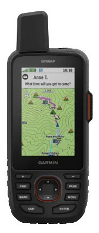
Learn more about the Garmin GPSMAP 67i here at Hiking Emergency Beacon.
Garmin GPSMAP 67i Features
- With inReach Technology
- Two-Way Messaging
- Interactive SOS Alerts
- Location Sharing with MapShare
- Longer Battery Life Over the 66i

- Up to 165 Hours in Tracking Mode
- Up to 425 Hours in Expedition Mode
- Track Your Position with Multi-Band Technology
- Expanded GNSS Support
- Get Access to Multiple Frequencies to Improve Positioning Accuracy
- ABC Sensors
- Altimeter
- Barometer
- 3-Axis Electronic Compass
- Download High-Resolution, Photorealistic Maps
- Pre-Loaded Maps of North America
- Outdoor Maps Subscription
- Access to Public Land Information
- Landowner Names
- Hunting Management Unit Boundaries
- BLM Boundaries
- 100% Global Iridium Satellite Network
- Garmin Messenger App
- The 67i Now Joins the Mini 2 with Access to the Messenger App
- Group Messaging
- Transitions between WIFI, Cell Service and Satellite Service, Automatically
- inReach Weather
- Active Weather
- Extensive Navigation Capacity
- Built to Military Standards for Thermal, Shock, and Water Performance
- Includes an LED Flashlight
- Get Automatic Cache Updates
What’s New with the 67i
The new Garmin GPSMAP 67i has a greatly improved battery life and now has access to the Garmin Messenger App, that allows for group messaging. The Messenger App also automatically switches between WIFI, Cellular Service and Satellite Service, which makes keeping in touch with family and friends that much easier.
Outdoor maps, with a subscription, gives you access to public land information, landowner names, BLM boundaries, and hunting management unit boundaries.
Click on the link below to learn more about the Garmin GPSMAP 67i or if you would like to purchase it.
Garmin GPSMAP 67i Rugged GPS Handheld with inReach® Satellite Technology, Two-Way Messaging, Interactive SOS, Mapping
- Large 3” sunlight-readable color display for easy viewing
- Enable two-way messaging and location tracking via the 100% global Iridium satellite network, and trigger an interactive SOS to Garmin Response℠, a 24/7 staffed emergency response coordination center (active subscription required; some jurisdictions regulate or prohibit the use of satellite communications devices)
- Access preloaded TopoActive mapping from Garmin, view satellite imagery, and navigate with multi-band GNSS support and sensors
- When paired with your compatible smartphone, you can access active weather forecasts and Geocaching Live
- Use with the Garmin Explore website or app on your compatible smartphone to help you plan trips and more
- Get access to a wide variety of premium mapping content delivered directly to your device via Wi-Fi technology with an Outdoor Maps+ subscription
This product was presentation was made with AAWP plugin.
GPSMAP 67i Specifications
Return to Home Page

Thanks for the training videos.
I just finished watching the first one. Having tried before with a Garmin 530 bike GPS, I feel that Garmin’s software engineering incorporates pretty clumsy user interface design. It is not intuitive and is much harder for me to learn compared to my iPhone or my MacBook Pro. So I do need to watch some training videos, rather than diving in.
From looking around at other online content, yours is the best I have found.
I will give you more feedback once I have viewed more of your videos.
Thanks for the thumbs up. Take a look at the 67i playlist as I took a lot of time to break down each feature into shorter videos to make it easier to learn how to use it.
Let me know if you have any questions. You can check out my YouTube channel for those playlists at https://www.youtube.com/@outdooremergencytech
Rick