Here is the latest field test of the Garmin Fenix 7X Navigation. I tested out the navigation on the watch and also using the Garmin Explore App. There is a difference and reasons why you may want to use both methods.
Follow a Waypoint on the Fenix 7X
There is one quick way to navigate on the Garmin Fenix 7X watch, and that’s to select HIKE, then USE MAP, select a point on the map, and then select GO.
The only problem with this method is that it will select the nearest road or trail to create the route. This will work great for most people on known trail or in a city, but it doesn’t work well when out in the mountains with no known trails around.
Create Route on Garmin Explore App
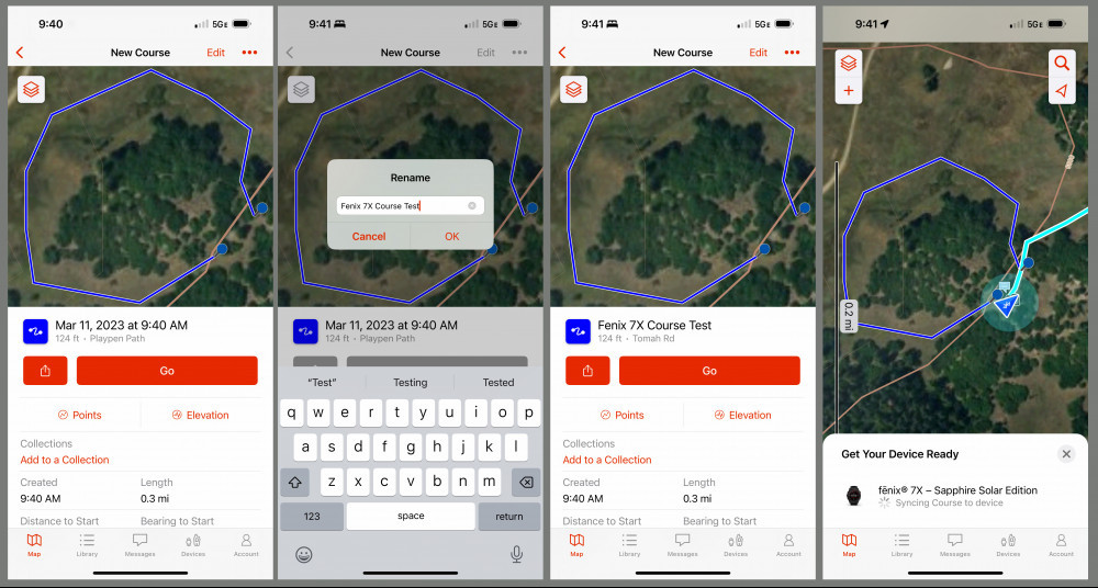
This method is much easier and more powerful. You can still select a point or points and navigate DIRECT or by ROADS & TRAILS. If you are near roads and trails, select the ROADS & TRAILS option, but if you’re in the mountains then you may want to use DIRECT, and select the points to define the course or route.
Select the “+” icon on the top left side of the screen, then select CREATE COURS, and then SAVE the course.
Now you can change the name of the course, select GO, and then start following the course you created.
You can choose to follow the course on the Explore App, or use your Garmin Fenix 7X watch to navigate.
It’s easier to create the course on the Explore App, but I find it more convenient to navigate on the watch as it’s easy to view the watch, rather than pulling the satellite communicator off my pack.
Final Thoughts
I find it best to create a waypoint and navigate to it on the watch when there are a lot of roads and trails around, however, it’s better to create a route on the Garmin Explore App, then select DIRECT, so you can follow the course created using the waypoints, while ignoring any roads or trails.
You can see more in the YouTube video below.
- Long-running solar powered multisport GPS watch with scratch-resistant Power Sapphire lens and always-on 1.4 inch display uses the sun’s energy to extend battery life; a built-in LED flashlight keeps you going after dark
- Battery performance: in smartwatch mode, up to 28 days while indoors or up to 37 days with solar charging in 3 hours of direct sunlight (50,000 lux) per day; in GPS mode, up to 89 hours indoors or up to 122 hours with solar charging continuously in direct sunlight (50,000 lux)
- Take your training to the next level with endurance and real-time stamina tracking, training status, advanced performance metrics and 30 plus built-in sports apps
- Get 24/7 health and wellness monitoring with wrist-based heart rate, Pulse Ox (not available in all countries), stress and enhanced sleep tracking (this device is intended to give an estimation of your activity and metrics; it is not a medical device)
- Navigate the outdoors with a higher level of positioning accuracy, thanks to new multi-band frequency and GNSS network support (GPS, GLONASS and Galileo) plus built-in sensors for 3-axis compass, gyroscope and barometric altimeter
- Find freedom and adventure with preloaded TopoActive maps — plus maps for thousands of golf courses and ski resorts worldwide
This product was presentation was made with AAWP plugin.
- Large 3 inch Sunlight-readable color display for easy viewing
- Trigger an interactive SOS to the geos 24/7 search and rescue monitoring center, two-way messaging via the 100% Global Iridium satellite network (satellite subscription required)
- Preloaded Garmin TOPO mapping with direct-to-device Birdseye satellite imagery downloads (no annual subscription), includes multiple global navigation satellite systems (GNSS) support and navigation sensors
- Cellular connectivity lets you access active weather forecasts and geocaching live
- Compatible with the Garmin explore website and app to help you manage waypoints, routes, activities and collections, use tracks and review trip data from the field
- Internal, rechargeable lithium battery provides up to 35 hours of battery life in 10-minute tracking mode and 1-minute tracking mode (display off), 200 hours in Expedition mode with 30-minute tracking
This product was presentation was made with AAWP plugin.
Return to Home Page


