Here is the 4th training video in the Playlist for the Garmin GPSMAP 66i Course Planner Training.


Course Planner Training
- 1st Test – Create Direct Course with GPSMAP 66i
- 2nd Test – Create Direct Course with iPhone 14
- 3rd Test – Create Course by Trail or Route with GPSMAP 66i
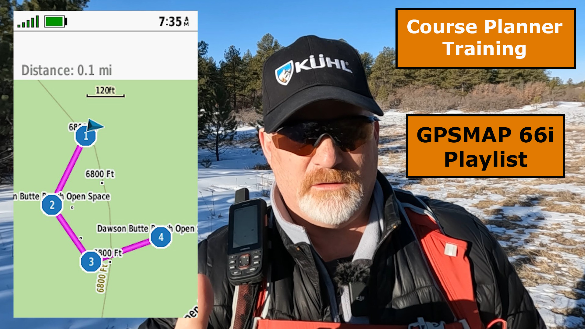
1st Test – Create Direct Course with GPSMAP 66i
Go to COURSE PLANNER, then CREATE COURSE, and choose DIRECT PATH, and SELECT FIRST POINT.

Go to USE MAP, then pick your waypoints and select USE, then select REVIEW.

Review the course, the select DONE, now select COURSE 002, and select GO.

Next, start hiking and watch your blue track behind you as you go. At the end of your hike, select STOP, then check out your activity stats.

2nd Test – Create Direct Course with a Smartphone
I like using satellite imagery when laying out a direct course with my smartphone as this helps me see potential ways through trees and around obstacles.
Go to the Map Icon at the top left of the screen. Select SATELLITE WITH TOPOACTIVE, then you will see higher detail for traversing around or through obstacles.

Now, select the”+” icon at the top left of the screen, then select CREATE COURSE, and start touching your smartphone screen to lay down the tracks through or around the obstacles in order to get to your destination.

The directions above and now what you are seeing here is starting to show some of the conveniences of using the Explore App to create a course, rather then only on the GPSMAP 66i device itself.
You now have the option to save the file with any name you want, then in my case, I had not stopped navigating from the last course, so a message popped up to ask me if I wanted to stop navigating with the last course and continue with the new course.

Next, you will be asked if you want to enable tracking. I selected ENABLE TRACKING, however if you want to save money and not be charged for tracking, you may want to SKIP this.
Now, go on your hike and after you reached your destination, remember to turn off tracking by going to DEVICES at the bottom of the screen and selecting the TRACKING icon with the check mark, and then select STOP TRACKING.

4th Test – Create Course Along Roads & Trails
Go to COURSE PLANNER, then to CREATE COURSE, then select ROADS & TRAILS, and now SELECT FIRST POINT.

Go to USE MAP, and now select your first waypoint, right where you are standing, then select your second waypoint where you want to end up. Now select REVIEW to see your course.

Select DONE after reviewing your course, then select DONE, and select COURSE 003. Now it’s time to go for a hike.

Select STOP after reaching your destination, then you can DELETE the activity, RESUME or SAVE.

Final Thoughts
The Garmin GPSMAP 66i is an extremely powerful satellite communicator, but the course and route creation is one of the things it excels at the most.
Please leave a comment or question below if you would like more information on the GPSMAP 66i.
Check out the field test video of this Course Planner and Course Creation training.
You can also click HERE to see all the training in the GPSMAP 66i training playlist.
No products found.
Return to Home Page
![]()