Check out my 1st Garmin inReach SOS Test with IERCC and see if it went well or failed.


The SOS Setup
First, make sure you schedule your SOS setup far enough in advance and make sure you know how far in advance. With IERCC, they suggest you schedule the test at least 72 hours in advance.

Next, make sure you read the instructions at least once so you know in advance what you will need to do, and then go over it again the day of your test.

Once you have your test set up, add it to your calendar so you don’t forget.
The Day of the SOS Test
Word of warning: It’s best to do the test when it’s not extremely cold outside. I inadvertently scheduled my test on the coldest day of this year in Colorado when it was “minus” 17 degrees (F).
The night before the test I made sure of my testing time, checked to see if my video equipment was ready to go and thought through the process and decided how much earlier I had to get up, as I also had to go to work after the test.
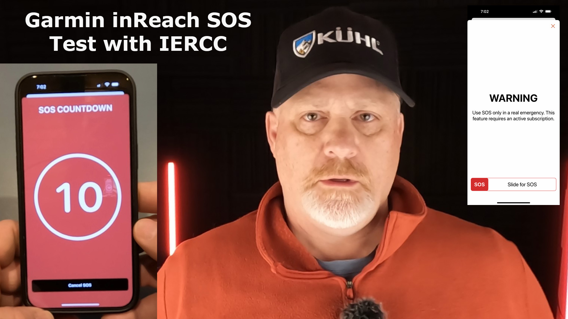
Alright, it was time to hit that BIG RED SOS button, and watch the countdown.

Note: I was using my Garmin inReach Mini 2, that was synced to my Garmin Messenger App, that uses cellular service or satellite service. Communication is much faster when in cell service.
IERCC contacted me easily within 30 seconds and I was on the phone with them within a minute.
The IERCC talked with me about my location, verified my contacts and emergency information. They were very pleasant and professional.
Lastly, they stayed on the phone with me as I canceled the SOS call.

Final Thoughts
This was a quick and painless SOS test and I strongly recommend everyone tests their device before heading out on your outdoor adventure. It sure helped me feel more confident that the SOS works and how professional and responsive the IERCC team is.
Watch this YouTube video of the actual SOS field test.

- Compact, lightweight satellite communicator enables two-way messaging and interactive SOS globally (Active satellite subscription required. Some jurisdictions regulate or prohibit the use of satellite communication devices.).Special Feature:Bluetooth.Water Resistant: Yes
- Navigate back to where you started by using TracBack routing
- Share your location with loved ones back home at any time (active satellite subscription required) by using your MapShare page or with your coordinates embedded in your messages
- Get accurate heading information using the digital compass — even when you’re not moving
- Sync with the Garmin Explore app and website on your compatible smartphone for trip planning and topographical mapping, and create waypoints, courses, activities and collections you can sync to your device
- Pair with Garmin devices, such as wearables and handhelds, and use them to send and receive messages and trigger an SOS (active satellite subscription required)
This product was presentation was made with AAWP plugin.

- Large 3 inch Sunlight-readable color display for easy viewing
- Trigger an interactive SOS to the geos 24/7 search and rescue monitoring center, two-way messaging via the 100% Global Iridium satellite network (satellite subscription required)
- Preloaded Garmin TOPO mapping with direct-to-device Birdseye satellite imagery downloads (no annual subscription), includes multiple global navigation satellite systems (GNSS) support and navigation sensors
- Cellular connectivity lets you access active weather forecasts and geocaching live
- Compatible with the Garmin explore website and app to help you manage waypoints, routes, activities and collections, use tracks and review trip data from the field
- Internal, rechargeable lithium battery provides up to 35 hours of battery life in 10-minute tracking mode and 1-minute tracking mode (display off), 200 hours in Expedition mode with 30-minute tracking
This product was presentation was made with AAWP plugin.

- Features rugged military-grade construction and a 5” touchscreen display that’s 50% larger than the previous model; offers easy viewability and includes versatile mounting solutions.Control Method:Touch,Application.Special Feature:Routable Topo Maps; Multiple GNSS Networks, ABC Sensors; inReach Satellite Communication; BirdsEye Satellite Imagery.
- Trigger an interactive SOS to the GEOS 24/7 monitoring center — two-way messaging via the 100% global Iridium satellite network (active satellite subscription required; some jurisdictions regulate or prohibit the use of satellite communications devices).
- Multi-GNSS (GPS and Galileo) support — plus preloaded TopoActive maps and City Navigator street map navigation; navigation sensors include 3-axis compass and barometric altimeter
- Pro-connected with ANT+ technology, Wi-Fi connectivity and BLUETOOTH wireless networking, giving you direct-to-device access to BirdsEye Satellite Imagery downloads, location sharing, Connect IQ app support and more
- Compatible with the Garmin Explore website and app to help you manage waypoints, routes, activities and collections, use tracks and review trip data from the field
This product was presentation was made with AAWP plugin.
Return to Home Page
![]()