Trail Information
Trail Name: Tanglewood Trail (Out & Back)
Location: Northwest of Bailey, Colorado
Trail Video on YouTube: Tanglewood Trail, Colorado
Date: September 21, 2019
Time at the Trail Head: 7:30am
Trail Length: 10.0 miles
Elevation Gain: 2,913 feet
Elev. at Trail Head: 9,319 feet
# of Hikers Passed: 12
# of Mnt. Bikers Passed: 0
# of Horses Passed: 0
Mosquitoes: 0

The Drive from Denver
This day started out picturesq as the drive from Denver to Bailey is relaxing and beautiful. Part of the drive takes you through Aspen Park and Conifer, which are two areas I would like to live in some day. Approximately 3 miles east of Bailey, you need to turn off on a county road to the northwest, that eventually leads you to the Tanglewood Trailhead, but not before passing though some incredible ranch land with beautiful forests and pastures along the way.

The trailhead is easy to find and is mostly asphalt until the last few miles. Watch out for some decent size potholes near the end but anyone in a car can make it to this trail.
My Day on the Trail
I arrived at the trail a little later than I intended but I was hiking at 7:30am. It was a beautiful crisp autumn day and the temperature was around 40 degrees.

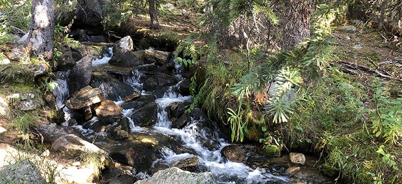
I could tell this was going to be a great hike because it was obvious the scenery was incredible and the rushing mountain stream was magnificent from the start of the trail.
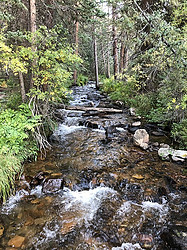 I had to cross the steam several times but it was always easy as there are wooden bridges or logs that have the tops flattened to make it easy to cross. The other stream crossings were not a problem as they all had large boulders that you could easily walk across.
There were many times I had to stop along this stream to watch and listen to the incredible sounds. You sometimes forget how beautiful it is to sit next to a rushing mountain stream. I could also see and hear squirrels, chipmunks and many kinds of birds over the sound of the stream.
Everyone I passed seemed to love being by the stream more than anything else on this hike.

The trail gets a little steep and rocky at times but for the first 3 miles, I would rate the trail as moderate. There were not many steep inclines and it was a rather gradual slope up. The switch backs were a nice gradual hike as whoever created the trail did a great job of picking the path up the mountain.

It wasn’t until around mile 3.5 that things became extremely challenging. This was also the time when I broke out above the tree line and started seeing magnificent mountain views. However, as I was between 11,000 and 11,500 feet, the altitude started to take its toll on me.

As you will see in the next picture, the trail is pretty, but it started to get steep and the amount of breaks to catch by breath doubled or tripled over what it was a half mile back.

After stopping to catch by breath I noticed a little friend in the tree. He was chewing or eating a pine cone and I had to sit and watch for a while to figure out what he was doing.

I realized that he was eating around the middle and he would chew and then spit a piece out and then stop to eat. He repeated this over and over. I believe he was chewing down to something in the pine cone that squirrels eat and I’m not exactly sure what that is.
I finally reached the high point of the trail but there was still a mile remaining.

I had met some hikers coming back down the trail and I asked them if they went to the end of the trail and they said, no. They said they had started down the trail but the views were all the same and they really didn’t want to hike back up the trail again before heading back down. This is where I had a dilemma about doing the same thing but I noticed Mount Evans off to the northwest (left part of the picture above) and I was sure there would be some great vantage points farther up the trail so I decided to keep going.
It was about another 1/2 mile down the trail that I notice two beautiful mountain lakes. They were both crystal clear lakes and the lower one had some great views out to the east towards Evergreen, Colorado.

The upper lake was just as beautiful and had some awesome looking boulders around it and had some incredible looking colors in the mountain behind it.

This is an area that I would love to come back to with friends or family and bring a nice lunch and be able to sit and relax and just enjoy the incredible scenery. It truly was relaxing and a beautiful place to hang out.
The Last half of the trail wasn’t that spectacular. The trail was difficult to follow and of course I was wiped out by now. I was able to get a little better view of Mount Evans to the west and the area around Evergreen, Colorado to the east but if you’re tired, then you aren’t missing much by turning back at the mountain lakes.


Lessons Learned
- Always read other recommendations for a trail, like you will find at AllTrails.com, and make sure you go to the end if the reviews are great, especially when there is a hidden gem at the end like a high mountain lake.
- I took this trail by myself and for the last mile and the last two hours, I was completely alone, high up in the Rockies. Even thought I had by SPOT Gen3 Emergency Satellite Messenger, I realized it would be smarter of me if I had a hiking buddy in case something went wrong, plus it would be great to share the experience with someone.
- Even though I arrived at the trail head at 7:30, it was really an hour later than I should have gotten there. As it often does in the Rockies, some weather started building in the afternoon around 2pm and it’s always smart to get off the higher altitudes due to the potential of thunder storms building suddenly.
Trail Recommendations
The Tanglewood Trail, northwest of Bailey, Colorado, is now one of by new favorite trails to take in Colorado. It’s only about 1 hour from Denver but it is isolated enough to not be heavily traveled and better yet, the mountain stream, the mountain views and the mountain lakes are worth taking time to get out and enjoy the Rockies.
This is a trail that I will definitely be bringing family and friends back to in the future.
One final note. If you are taking someone on this hike who can’t handle the distance or the altitude, then just stay on the first 2 or 3 miles of the trail and you will have enough beautiful scenery to make everyone happy.
I spent 9 hours on the trail and I was wiped out. I think you could hike the trail in 7 hours or less but I would allow for some extra time at the lakes to relax and have a nice lunch.
Enjoy more of the trail by watching my short video below of Hiking Trails in Colorado Tanglewood Trail.
Please leave a Comment Below or Email me if you have any questions or have another trail you would like to recommend.
Return to Home Page
![]()
Tanglewood Trail, Colorado
FreePros
- Easy Access
- Incredible Views
- Mountain Stream
- Mountain Views
- Mountain Lakes
Cons
- Difficult Hike Near Top
- Length if Hiking Entire Trail
- Rocky Trail at Times
Hiking isn’t one of my favorite thing but definitely something my kids love I would love to experience it in this location since the trail is wide enough for a good stroller and for the initial part of the trail which helps when you are going with kids. There is ample parking too and this is also an added advantage.
I’m not sure how well a stroller would work on the trail. It may be okay in the first 1/2 mile to 1 mile as long as it had the larger wheels for gravel.
There are a lot of trails around Conifer and Evergreen that are wider and really well maintained with smaller gravel that would be better for strollers and young children. However, I did see one young couple with a one year old in a pack where you carry them in front of you. I don’t think they went more then a mile up the trail but it was a great place for a nice hike for them.
Rick
Beautiful country side. I also love mountain views as I am staying in Barberton on the foot Makhonjwa Mountains, now declared a World Heritage site. Mountains just have a calming effect on me always. I used to hike when I was younger and I think I must take it up again. What would suggest I sould include in a bag for a day trip as I would be starting up as a newbie again?
Wow, what lovely pics!
This looks like a lovely place. We are looking to plan some hiking trips for nest spring/summer season.
Colorado look amazing for views, but I am wondering whether there wold be any high top accommodation like a cabin up high on the tanglewood trail. As we don’t want to rush anything and love the rush of camping about.
Thanks a bunch
Ropata NZ
There are hundreds of cabins to rent in the area from Bailey, to Conifer to Aspen Park and Evergreen. I personally saw many cabins I know are available to rent within 5 or 10 miles of the trailhead.
Rick
Beautiful country side. I also love mountain views as I am staying in Barberton on the foot Makhonjwa Mountains, now declared a World Heritage site. Mountains just have a calming effect on me always. I used to hike when I was younger and I think I must take it up again. What would you suggest I should include in a bag for a day trip as I would be starting up as a newbie again?
I just looked up the Makhonjwa Mountains and they are beautiful.
First, I would start with a great day pack that is the right size and is meant for day hiking. I use the Osprey Talon 22, which is a 22 liter pack. I would make sure you have a great first aid kit, an emergency hiking beacon, enough water for your trip, appropriate snacks for energy, layers of clothes for changing weather, sun screen, bug repellent, rain jacket and a rain cap. Those are the major things I would start with but don’t over pack either. Only take what you know you will need, and check the weather before you head to the trailhead.
Rick
The pictures are beautiful. I used to hike in the mountains of Tirol, in Austria, and it reminded me a little of that. It was always so beautiful, being connected with nature, and the water of the mountain streams was always so clear and fresh. I should do it again soon, but in a different country, perhaps the US ;-). Some people told me that Colorado has amazing landscapes, and I would love to go and see for myself, possibly go on a hike too 🙂
The mountains in Colorado, the views are amazing. I loved that one picture with the view over the mountains! Lovely that you met one of the mountain’s residents, the little squirrel in the tree. That’s also a great picture by the way. How did you take this photo without scaring the little guy (or gal) away? What camera do you use?
Did you dip your feet in the mountain lakes? It would be so refreshing after such a long hike. Seriously, reading about your hike and seeing the photos makes me feel as if I was there too. I would love to explore that trail. I’ll make sure to have a hiking buddy, like you recommend 🙂
Thank you for the wonderful comments. Actually, I was so exhausted, and by myself, that I never thought about taking my boots off and cooling them off in the lake. I should have done that. I will remember to next time.
I use a iPhone 6 for all of my pictures but I want to look into a better camera for the trail. I was also making a video, which I am about to post on YouTube, and I noticed that in only 9 hours, my phone went from a full charge to 20% in that short of a time so I really want something better that has a better battery.
My little friend was really courageous or hungry. I didn’t notice him until I sat down, from exhaustion, and then I saw him not more than 10 feet away just eating and getting ready for his or her long winter nap.
Thank you so much for stopping by and asking some great questions.
Rick
Thank you, great article! I appreciated your story of your hike. So, the squirrel was eating the center of a pine cone? That’s very interesting, I’ve never seen them do that. Sorry if I missed it but what time did you get back? And did you bring any lunch to eat on the trail or did you just eat somewhere when you got home?
This sounds like a really nice Trail and I would like to give this a try with friends or family. Great job doing this hike and I look forward to reading more of your hiking stories. Also, thanks for the very interesting squirrel information.
Thank you for reminding me to put the length of time on the trail. I took several hours longer than someone in great shape and I spent 9 hours on the trail. I had 3 liters of water and trail mix. I was never really hungry but I could have made some better choices on food.
When I go back, I want to be in better shape, and have a nice lunch with sandwiches, fruit, etc to eat at the lakes, but I don’t want to pack heavy for that. I think you actually need to add 1/2 hour to your time at the lakes to relax before you will even feel like eating. I know I lose my appetite sometimes when expending a lot of energy. I didn’t feel like eating until about 7pm as that hike really exhausted me and I went home, showered and fell asleep.
Rick
Hi,
Great post about Hiking trails in Colorado.How natural the way you describe everything when I was reading I was thinking I am visiting there. After reading your post it seems I can’t wait to visit. But unfortunately, this year is not possible but my younger brother is going to visit next month in Colorado and I heard about and he has an interest in the trail, so I am going to share this post with him and hopefully, he will get a ton of information about Colorado and the trail. Thanks a lot.
Thank you for the compliment and tell him to feel free to read up on the trail and send me any questions he has.
Thank you for stopping by.
Rick
I really enjoyed reading through this and I really loved it. You’ve said so many things about the Hiking Trail in Colorado, so many interesting views to experience. Please do you know of any agency that organizes something like a trip or holiday to This Hiking Trail in Colorado?? If yes, please drop their details so we can reach them and know when it will be. I’ve enjoyed every line of the article, its really nice .
Hi Jones. I don’t think there are significant outfitters working this trail, but that is my opinion and not a fact. If you’re wanting guided trips, I would take a hard look at the area around the Rocky Mountain National Park. I have seen many outfitters in that area that have hiking trips of all lengths and some that even go over the mountain passes and may be 5 days or more on the trail. Here are a few links for you to check out.
https://www.wildlandtrekking.com/colorado-hiking/day-hike-tours.html
http://www.kirksmountainadventures.com/our-trips/
https://www.visitestespark.com/things-to-do/tours/
I hope this helps. Let me know if you have any other questions.
Rick
Great review!
I’ve being there before, it was an awesome 10mile hike in and out. It started raining after 1pm. There were great views and different scenery throughout hike. I recommend it. I would say its a moderate trail. I carried along about an extra 35lb toddler on a backpack no problem. Incline was actually the hardest at the end after the switch backs. Dog friendly and light to moderate traffic .
I agree that it is a moderate trail for the most part, but it became hard for me at the top, however, I do need to drop about 70 more pounds. That could be a little factor in my difficulty.
Thanks for your experience on the trail. I want to go back but there are many other trails I still have to go experience.
Rick
plenty of parking and some great hiking trails. saw a bear and two moose within 20 minutes of each other last time I was on the rosalie trail. the sound of the creek is so relaxing to.
Great hike saw bull moose. Got rained on the trail was wet with running water in places.
I didn’t see any large wildlife but I did see a lot of squirrels. I made the hike yesterday, September 21st which is a more dry time of the year so I could see where the creek would be more challenging when it rains more or when you have a lot of snow melt.
Thank you for sharing your experience on the trail.
Rick
I love hiking but I have never hiked in the Rocky Mountains. I am from the Northeast and I am used to hiking in the Appalachian Mountains of New York and New Jersey. I know there is a big difference as far as terrain and difficulty but one day I would like to try trails in Colorado. I also want to visit CO because I am a big fan of craft micro brew beer and I know there are some great breweries there.
I can relate to when you said that you had to stop next to that stream to watch and listen to the sounds. I actually found my favorite hiking trail because of a mountain stream. Was going hiking and parked at the trailhead but it was about an 8th of a mile from the stream so I backtracked and actually found a trail I never knew was there that lead back to the stream, but then it proceeded up the mountain along the side of the stream.
Naturally I had to see where this mountain stream was coming from so I took about a 35 minute hike up the rocky trail and found a mountain top lake and another mountain on the other side with an old stone tower at the top. Again naturally I had to investigate and spent another hour to get to the very top. Hiking is a great way to experience nature and get some exercise too. – You say your hike was 10 miles. About how long did it take you to complete it?
Hey Robert. That hiking trip sounds like a lot of fun.
I spent 9 hours on the trail but could have done it in 7 hours or less, depending on the shape a person is in and if they want to explore other areas or take time to relax.
I was really exhausted when I returned home. I’m starting to think about looking for shorter trails that may be 3 to 6 miles in length to I have time to explore and not be completely wiped out when I get back to the truck.
Rick