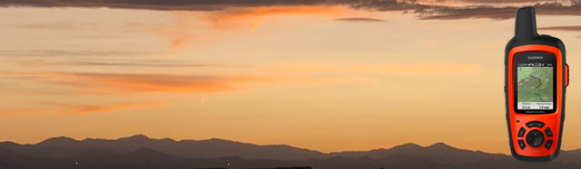
Does anyone really need a Hiking Safety Beacon?
I have hiked for over 30 years and I never needed one…or did I?
![]()
You Never Know
I have come close to life threatening emergencies many times over the past 30 years but as many of us believe, nothing bad will ever happen to us.
If you ask me now at the age of 54 if I think a Hiking Safety Beacon is important, I would tell you…ABSOLUTELY YES!


Why Do You Need an Emergency Safety Beacon?
- Life-Threatening Situations Will Occur
- Hiking Alone Needs a Backup Plan
- Possible Emergency at Home
- Stories of Hikers With an Emergency Safety Beacon
Life-Threatening Situations Will Occur
After hiking for more than 34 years I have encountered my share of potentially life-threatening situations, even though I knew nothing would ever happen to me or anyone in my group.
Mount Bailey, Diamond Lake, Oregon
My first scare with severe injury or worse came while hiking Mount Bailey near Diamond Lake, Oregon. My dad, myself and a friend of his were hiking up a rock fall and were not on a trail. My dad’s friend who was higher up decided to have a little fun and dislodged a large boulder, sending it down the mountain towards me. It passed within 50 feet of me and let’s just say that even though I was exhausted, I found enough energy to move out of the way at lightening speed.

This also goes to prove that men on hiking trips can be stupid and immature. I know, as I have also done my share of stupid things out on many adventures.
Latir Peak, Red River, NM
My second brush with death occurred on Latir Peak north of Red River, NM. We were hiking around and had not planned to hike to the top of Latir Peak. We were enjoying some grand views looking north at the Latir Lakes when someone in our group had a brilliant idea that we were not far from the peak and if we just scaled this steep cliff, we would be there in no time.
Word of warning. It’s not the smartest idea to make unplanned diversions. We were most of the way up the cliff when the climb became serious. We were crawling up the cliff, watching a hawk circle below us, and realized we were in a bit of a jam. Sometimes it can be harder going back down then continuing on up and you know guys. No one is going to admit it was a stupid decision to scale this cliff.
Of course, no one was injured, but there are many stories of hiking groups where things turned out badly.
Upper Buffalo River, Harrison, AR
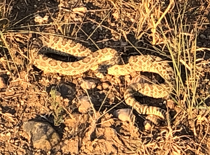
I believe this was the first trip that we took my son, Caleb on. It was a beautiful day and two of my nephews, a friend, myself and Caleb started off on our 3 mile hike into the Buffalo Wilderness Area. We were not more than a mile into the hike when my son and one of my nephews almost stepped on top of a large rattle snake. I believe it was 5 or 6 feet long. To say the least, this could have ended badly.
On the same trip, my son and two nephews were doing there best to dam up the Buffalo River when my son picked up a rock and a small water moccasin slithered out into the river. I’m not sure which snake is more venomous but I don’t think it matters much. We were a good 3 miles away from the truck and someone would have had to run out for help and of course, there is never any cell service.

It was interesting because we had several conversations on that hiking trip about what we would do if we had a life-threatening situation. We decided that our best bet would be to send the fastest hiker who was in the best shape out for help, but if you’re bit by a venomous snake, that may not be fast enough. We were also not carrying any snake bite kits with us at that time. That changed after that hike.
Cabresto Lake, Red River, NM
On a return trip to the Latir Peak Wilderness Area in mid September, we had the unfortunate experience of encountering a freak early snow storm. We were in 1.5 feet of snow and thought there wouldn’t be any problem but with a thick blanket of snow covering the area, we discovered, after looking at our maps, that we were on the wrong side of the mountain peaks and heading into unknown territory. We turned around and followed our tracks back to safety but this is another situation that has turned out poorly for many other groups.
Upper Buffalo River, Harrison, AR
We took a second trip to the Upper Buffalo River in NW Arkansas but decided to try a new trail. We were half-way into the trip when we came upon a really spectacular bluff along the river. We were approximately 300 feet about the river at Big Bluff and it was a vertical drop to the river. It was a gorgeous view but one of my nephews, who will remain unnamed, but his name is Christopher, decided it would be really cool to climb out on the tree that was out over the cliff.
Christopher is still alive today but I wanted to kill him if he didn’t die from stupidity. I was nearly panicked watching him climb out on the tree and there was nothing I could do or say that would bring him back.
Thankfully he didn’t die and also that I didn’t kill him after him got back on solid ground.
The Bluffs Regional Park Trail, Lone Tree, CO
 Recently, I was enjoying a hike near Lone Tree, Colorado on a bluff overlooking Denver and the Rocky Mountains. I was walking along when I heard a distinct sounding rattle and stopped to see where my little friend was. He or she, was about two feet away from me and was not happy that I was invading its territory. This is another example of a wonderful hike that could have ended badly and does for some people.
Tanglewood Trail, Bailey, Colorado
I decided to take a pretty tough 10 mile hike on the Tanglewood Trail, northwest of Bailey, Colorado. I didn’t have my Emergency Satellite Messenger yet but I knew I would be fine, so I started out on the trail.
It was an incredible hike with a gorgeous stream flowing down from the mountain for the first three miles. It was a beautiful sunny day and what could be better than spending it in the Rocky Mountains.
The hike became more challenging when I reached the 11,500 foot elevation point. I have been in Colorado for 3 months now and am slowly getting use to the altitude but I was sucking wind at this point. I finally reached the high point in the trail but there was still a mile to go, on an out and back trail. I met some hikers heading back to the trailhead and I talked to them for a few minutes. They said that they didn’t go all the way to the end of the trail, as they didn’t want to hike back up to the “saddle” before heading back down. They also said they didn’t think there would be any better views farther down the trail. Were they ever wrong.
I came across two beautiful mountain lakes and I wished I had my wife or some friends with me to enjoy a nice picnic in the mountains. I finally found the end of the trail when the clouds started building. I had been above tree line for the last hour and a half and it’s never good to be up there if a lightning storm hits. It turned out that the storms did not turn into thunder storms but it was still difficult for me to hike back up to the saddle before reaching the easier downhill sections.
I spent 9 hours on the trail and was completely exhausted. I was by myself for at least 2 hours on the trail up around 12,000 feet and I had to rest about every 50 feet. I was getting dizzy at times and was slightly nauseous. My daughter, who is on the Mountain Search and Rescue Team, in Gunnison, Colorado, told me it sounded like I was at the beginning of having altitude sickness, which can be extremely dangerous.

It didn’t help that I was exhausted, alone, without any communication device or Emergency Satellite Messenger. No one else was up there and as I was heading down the mountain, no one else was heading up so it’s possible that I would have had no help from other hikers if I had really gotten into trouble.
This hike taught me two lessons. First, don’t hike alone, especially on difficult hikes and secondly, always have a Personal Locator Beacon or an Emergency Satellite Messenger on you in case you do need it.
You can learn more about these emergency safety beacons here in my Emergency Radio Reviews.
Hiking Alone Needs a Backup Plan
I will keep this short and sweet. If you are on an easy trail, especially on a trail that is heavily traveled, then you’re fine hiking alone, however, if you are on a difficult trail that is lightly traveled, then I highly recommend that you have a hiking buddy and an emergency satellite messenger. If you don’t have these, then change your plan and head to an easier trail where you can get help if you need it.
Possible Emergency at Home
We often don’t consider that the emergency may be at home and not on the trail. Wouldn’t you want to have an emergency satellite messenger if something terrible happened back home and someone really needed to get in touch with you? Enough said.
Stories of Hikers With an Emergency Safety Beacon
- A couple decided to go Bushwalking at Govetts Leap in the Blue Mountains west of Sydney, Australia. Not long into their hike, they were alerted by a hiker that there was an injured person ahead of them on the trail. The hiker was planning on alerting search and rescue teams in the area once he could call for help, however, the couple reached the injured person first and was able to determine that the injury was severe and help needed to be called immediately. They used their Personal Locator Beacon to call for help and search and rescue teams were able to respond quickly and a helicopter was able to land nearby and airlift the injured hiker to safety. This is a perfect example of how you think nothing serious will ever happen to you but you never know when your preparedness may help someone else.
- A group of snowboarders headed into the mountains at Egypt lake hut in Banff, Alberta, Canada. It was a great time in the mountains until the return trip when two skiers misjudged a ridge line and fell 20 feet to an icy landing below. One person was bleeding from the neck and couldn’t stand. Two people in the group headed out to get within cell phone reception so they could call for help, while someone in the group activated their emergency satellite messenger. A helicopter was dispatched to the area and within two hours, the injured hiker was airlifted to a nearby hospital to receive much-needed medical attention. This is another example of the person with the emergency beacon not needing the assistance but was able to call for help for another person in their group.
Lessons Learned
Nothing will ever happen to me!
You may be right, and I have often thought this way but the reality is, if you go on enough outdoor adventures, something will most likely happen to you and it will for sure happen to someone you come across someday.

As you can see from my close calls, I have nearly needed help multiple times and there are thousands of stories around the world each year where people who were prepared were able to help to get someone medical attention quickly and more importantly, help to save someone’s life.
Be prepared, not only for yourself, but for someone else as well.
I hope you can now see the importance of emergency location devices. You can learn more about Personal Locator Beacons HERE and Emergency Satellite Messengers HERE.
Check out these top 11 satellite messengers of 2023 in this YouTube video below.
Please leave a Comment Below or Email me if you have any questions or would like to share your experiences.
Return to Home Page

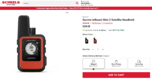
- 100 percent global Iridium satellite coverage enables two way text messaging from anywhere (satellite subscription required)
- Trigger an interactive SOS to the 24/7 search and rescue monitoring center
- Track and share your location with family and friends. Water rating : IPX7. Battery : Rechargeable internal lithium ion
- Pair with mobile devices using the free earthmate app for access to downloadable maps, U.S. NOAA charts, color aerial imagery and more
- In reach explorerplus device adds preloaded Delorme topo maps with onscreen GPS routing plus built in digital compass, barometric altimeter and accelerometer
This product was presentation was made with AAWP plugin.
![]()
I absolutely enjoyed reading your post. You are quite the adventurer and I feel like your stories were written in a way that I could feel what you would have been feeling. Such a great job.
The adventures that you took and all the close calls, are the perfect lead up to why people should buy an emergency safety beacon. Each one of your stories could have easily gone a completely different way and had disastorous consequences. I am so glad they didn’t
Anyone that is a hiker is really going to fall in love with your stories and all the crazy things you do. Your are crazy!! But good crazy. You seem like you are living your best life and your website could save a life.
Great job
Thank you for the compliments. I’m amazed that I have lived this long with as many things that have happened to me during my life. I hope people, especially young people, will listen and learn from some experience that we are not invincible and things happen all the time that we never imagine will happen.
Many times it may not be about what happens to us, but what happens to others that we can be an instrumental part of something good happening, or at least a better outcome.
Rick
One of the things on my bucket list is climb a mountain.. Haven’t decided which one yet.. Mountains can be such a amazing view to see..But to climb them can turn in a death trap.. Thank you for safety tips, people don’t realize the safety tips until it’s too late..You are very thorough.. And your article is definitely an eye opener.. When I eventually take my trip to climb my first mountain I’ll be sure to be prepared…Really good read..Best of luck
Thank you for stopping by and letting me know about your future plans and bucket list.
Please come back and let me know what mountain you do end up climbing and how it went for you.
Rick
Thank you for writing this useful post on hiking safety beacon, hiking safety is part of the product so that should tell us something. Hiking can be very dangerous especially at altitude, you have mentioned yourself how many times you came close to a life threatening accident. By recommending this type of product you may actually save someones life, well done on raising the issue and solution to hiking accidents.
Fintan
I hope that some outdoor adventurers will pay attention and find something that will help them call for help or message family and/or friends.
I’m a little embarrassed that it took me this long to wise up.
Rick
I would like to share an experience that happened to me in the college days. I and my friends went on a mountain trail running and along the line, we decided to split up so that everyone could come up with different photographs apart from what the other person has. It was all going smoothly until I came across a black mambas and I had to make a run for it and as such, I lost the track of my route back to my friends. To be honest, It took almost 6hours before they found me when it was getting late already because I did not have a beacon on me.
I’m glad it ended well but there are so many things like this that we never plan for or don’t think will happen to us. I really like the 2-way emergency messengers that allow you to message each other in addition to having the SOS function. You could have used it on that hike.
I will leave a link below to my favorite emergency satellite messenger.
https://hikingemergencybeacon.com/garmin-inreach-explorer-review/
Thank you for sharing you experience with me.
Rick
Thank you for sharing this. I love going hiking in the local mountains, but rarely anyone happend to wonder off and never to be found. I agree with you that taking precautions is important. Especially in the winter time. Here, there was 2 older guys that lost their lives because they got caught in the snow storm. Of course, they did not have a beacon.
That is why this season I’m buying my first safety beacon. I am an experienced hiker, but you never know.
It took me 34 years to get smart enough to figure out that I needed a backup plan or “insurance” when out hiking.
Thank you for stopping by and saying hello.
Rick
Thanks for sharing this important life story to all hikers in the universe because you have helped them to know why they need an emergency safety beacon because it helps in alerting people if someone is in trouble for easy first aid all in all thanks for advising all hikers about the safety beacon
It’s always best to learn as much as you can from others, including their mistakes or close calls.
I guess that’s why some younger folks are smart enough to pay attention, at least a little attention, to those that have spent many years gaining all of their experience.
Rick
Thanks for sharing all these close calls with u to remind us on the reasons we need to get ourselves safety beacons. Sometimes it is good to dare the devil but on most occassion, it is totally not advisable to try that out with one’s life. All these you have shared are enough reason for me to ensure that I buy one of the safety beacons to ensure that I will be able to reach out for help on days of emergency.
Hi Shelley. Thank you for stopping by and letting me know that you’re one of the smart ones. I was not so smart for over 30 years but there’s time to correct that for me.
Let me know what safety beacon you end up getting.
Rick