
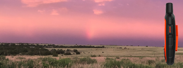
There is one Emergency Satellite Messenger that seems to stand out from the crowd and it’s the Garmin inReach Explorer.

Breakdown of what the Explorer Offers
- SOS Distress Call – 24/7 Rescue Monitoring Center
- 2-Way Messaging
- Built-In Navigation
- Pre-Downloaded DeLorme TOPO Maps
- Pair with Compatible Mobile Devices
- 100% Global Iridium Satellite Network (Pole to Pole)
- Track & Share Your Location with Friends and Family
- Built-In Compass
- Barometric Altimeter & Accelerometer
- Weather Forecasts
- Unlimited Cloud Storage
- Additional Aviation Services
- Built for the Backcountry
- Affordable, Flexible Satellite Airtime Plans
Let’s drill down into each of these incredible services. It’s actually amazing that all of these are in one device.
SOS Distress Call
I have to put this one right at the top as a life-saving SOS call could change your life. Having this at your disposal, anytime, anywhere, from pole to pole cannot be over-stated.
You can trigger the INTERACTIVE SOS call to the 24/7 search and rescue monitoring center, located in Houston, Texas. GEOS has a long history of responding to emergencies worldwide. They have supported rescues in over 140 countries and they are standing by 24 hours a day, 365 days a year. GEOS will track your device and notify local SAR teams that are in your area. While help is on the way, they will continue to text back and forth with you, providing critical updates and you in turn can provide them with detailed information so they will have a better understanding of your situation when they arrive. No one thinks a life-threatening event will happen to them, but it does, and we should all be prepared for it.
2-Way Messaging
The Garmin inReach Explorer is a true Satellite Communicator which is better known as a Satellite Messenger.
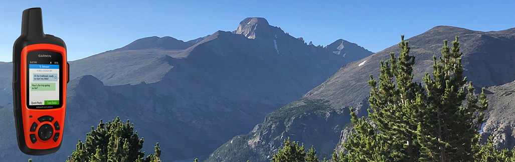
No one wants to be fighting for their life in the wilderness, but if you were, wouldn’t you want to be able to text life-saving critical information to your family and friends?
What about non-life-threatening messaging? This will be dependent on if you want to be bothered when you’re on an adventure but the thought of being able to know if there was a critical emergency back home that you would want to cut short your trip for is invaluable. It goes the other way as well. There are many times that we have emergencies that are not life-threatening or at least not yet, and I personally would have liked to message someone for assistance several times.
You can exchange text messages with any cell phone or email address in the world. Your’re not in cell service, that’s not a problem due to the global iridium satellite network. You can message people anywhere as long as you have a view of the sky, plus you can share your journey with friends and even social media.
Built-In Navigation
I believe this is one of the subjects that many of you were waiting for.
Don’t know where you are or trails show up that were not there when you were planning your trip? With the Explorer in your pocket, you don’t have anything to worry about.
The Garmin inReach Explorer adds pre-loaded DeLorme TOPO maps. You can even pair your Explorer with compatible mobile devices using the free Earthmate app for access to downloadable maps, U.S. NOAA charts, color aerial imagery and more. When paired with your smartphone, this inReach Explorer goes to a whole new level.
You can sync the inReach with your compatible Apple or Android device which makes text messaging even easier. The one thing your mobile phone can do a little quicker than the Explorer is, create new, unique text messages, and this is all possible when your are synced.
100% Global Iridium Satellite Network
This is a proven and reliable “pole to pole” network that actually covers the entire earth. If you are concerned about the coverage of some of the other models, then stop here and choose either the Garmin inReach Explorer or the Garmin inReach Mini. Both of them use this same network.

This is truly a tested and reliable network of satellites and 24/7 rescue monitoring center operated by GEOS. When you want to send or receive messages, navigate far from home or know that you SOS distress call will reach the right people, then this is the system you want on you.
This go-anywhere satellite messenger gives you all the luxury in the world, at least to an explorer, and you can rest assured that you can use your device anywhere you go.
No products found.
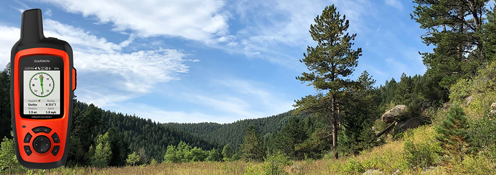
Track and Share Your Location
You may not want to share everything but when you’re out away from people and any chance of service or rescue, your friends, family and even your social network can track your location and know you are doing fine.
![]()
Turn on your tracking service of your Explorer and you will be able to communicate with your friends and family by allowing them to follow your progress on their computer or mobile devices using the web-based MapShare portal. The Garmin inReach Explorer will send waypoints at pre-selected time intervals, so everyone can track your location online. You can also invite people back home to use MapShare to ping your inReach Explorer and see your GPS location, track your movements and exchange messages on your trip. You can even embed your MapShare page on a blog, website or social media site.
Built-In Compass and Barometric Altimeter
You may also like the added benefit of the built-in compass and barometric altimeter. I can’t tell you how many times I have wanted to know what altitude I was at. Not that it matters much, at least for me, but it is just something I am curious about.
The Garmin inReach Explorer has a built-in digital compass, barometric altimeter and accelerometer. In case you aren’t sure, an accelerometer measures acceleration, typically of an automobile, ship or aircraft.
Weather Forecasts
Would you be interested in checking in on the weather on extended trip, especially when it looks like things are going to turn for the worse?
The optional inReach weather forecast service provides detailed updates directly to your inReach Explorer, compatible smartphone or tablet paired with the EarthMate app, so you’ll know what weather conditions to expect en route. Basic and premium weather packages are offered and you can request weather forecasts for your location or any other destination on your journey.
Unlimited Cloud Storage
The Garmin inReach Explorer comes with free access to a cloud-powered Garmin Explorer website to plan your trips with routes and waypoints. You can create preset messages and quick texts, sync and manage your device settings, update your firmware, download additional TOPO maps, link your social media accounts, store all of your location tracking data and more.
Additional Aviation Services
Your Garmin inReach Explorer is also a supported device for the Lockheed Martin Flight Services (LMFS) Adverse Condition Alerting Service (ACAS), Surveillance-Enhanced Search and Rescue (SE-SAR) and Enhanced Special Services (eSRS). You can find out more about these service at Garmin inReach Explorer’s website.
Built for the Backcountry
This is a tough and durable, impact resistant and water-rated to IPX7. The inReach Explorer handheld satellite messenger will keep you up and running no matter what mother nature throws at you. An internal rechargeable battery comes standard so you can count on long battery life in every mode of operation. The inReach Explorer can last 100 hours at a 10-minute tracking mode, which is the default setting, and up to 75 hours at 10-minute tracking with 1-second logging, and up to 30 days at the 30-minute interval power save mode. It can last up to 3 years when powered off. Recharge the Explorer via the standard micro USB power cable or optional in-vehicle 12 V charger.
Affordable, Flexible Satellite Airtime Plans
I can list the Satellite Subscription Plans for you here or you can see for yourself at Garmin’s Website. Just CLICK HERE for the four available plans.
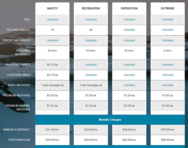
As you can see, they have annual plans (paid monthly) starting at $11.95 and monthly plans (called FREEDOM PLAN) also paid monthly starting at $14.95.
My Final Thoughts
I have been on adventures my entire life and it has been only recently that I have given much thought to having a great SOS distress call, navigation, 2-way messaging, weather forecasts and so much more.
There have been many times I went out hiking or backpacking to get away from people, noise and technology but something has changed for me now. I still want to be left alone on a trip to the mountains but I also love to be able to navigate when I need to or request a weather forecast when the skies start turning ominous.

The Garmin inReach Explorer+ really is at the top of the hill. This is something that we should all have in our packs when venturing out on an expedition.
Please Email Me with your questions or thoughts on the Garmin inReach Explorer Review or Leave a Comment Below.
You can also explore more Satellite Messengers models HERE or Personal Locator Beacons (PLBs) HERE.
No products found.
If you would like to see all the Satellite Messengers in another review, see my Emergency Radio Reviews.
Checkout the Garmin GPSMAP 67i that replaces the Garmin Explorer+ in this YouTube video below.
Return to Home Page
No products found.
![]()
Garmin inReach Explorer

Pros
- 2-Way Messaging
- Built-In Navigation
- Pre-Downloaded TOPO Maps
- Global Satellite Coverage
- Long Battery Life
Cons
- Size & Weight
- Initial Purchase Price
Hi! I really like the 2-way messaging feature. Yeah, it can be a game changer to have it out there in the wilderness.
Besides using the GPS constellation to give position, does Garmin inReach also rely on other constellations such as GLONASS or Galileo. If it’s not this model, is there another that receives signal from any of these other two constellations? Thanks in advance.
Hi Henry. Thank you for stopping by and asking a great question.
The Garmin inReach Explorer only uses the Iridium Satellite Network that is global and has pole to pole coverage.
None of the other Satellite Messengers or Personal Locator Beacons (PLBs) use the two satellite networks that you mentioned.
You can see the other devices I reviewed in the link below and the satellite networks they use.
https://hikingemergencybeacon.com/emergency-radio-reviews/
Please let me know if you have any other questions.
Rick
I really didn’t know this kind of signal existed when I went on an excursion to one of the west Africa game reserves last year. The experience I had was one hell of a thing that can’t be forgotten. The place lacked regular network signal and it is very far from the city. The worst experience was when the rain started falling and our bus sunk inside one watery area that came up as a result of the rain. We couldn’t get a signal to call for help. We were helpless when trying to get the bus back to road and at the same time we were panicking that the wild animals wouldn’t come out at that time to visit us. It wasn’t funny at all. Had it been I could have had Garmin inReach Explorer, it would have helped us reach out for emergency very urgently and we could have foreseen the weather condition before embarking on the journey. Now my question about this Garmin inReach Explorer. Does it have a separate antenna or it is combine together with device? Is it using battery or is it solar dependent?
Wow, what a story you have and you’re right that the Garmin inReach Explorer would have been perfect for that situation.
The antenna is built into the device so you don’t have to extend an antenna to get reception.
The internal, rechargeable battery, will last about 100 hours in the 10-minute tracking mode and up to 30 days at the 30-minute interval power save mode.
If I were traveling out of the country or going on a long trip, I would also take a portable charger like the one shown here:
https://hikingemergencybeacon.com/accessories/
I hope this helps. Let me know if you have any follow up questions.
Rick
Very nice post here on the garrmin inreach explorer. I have not given this one a shot before but it looks really good though. Been able to reach out to the outside world sounds pretty good and this device is the best go for that, especially when someone is going on a hiking expenditure. Very nice that it has unlimited cloud storage too. I should give it a go.
It would be a great choice and one you would be extremely happy with. I don’t like to be bothered when I head to the mountains but having this with me for emergencies, messaging (when I want to message and not when my wife wants to), navigation and weather forecasts, would be beneficial.
Thank you for stopping by and sharing.
Rick
This is a really lovely post and a very useful one too. I read about Garmin inReach explorer once but not a detailed one like this, this article has given me a complete insight of what its all about in full dimension. Garmin inReach Explorer has really surprised me by virtue of what they offer and how it works. I really look forward to getting one for myself cos I travel a lot. Thanks for this post, its really interesting reading through.
Hi Jones. This has become my number one choice. The Garmin inReach Mini is another great one for shorter hikes and backpacking trips but if I were traveling and going on longer adventures, the Garmin inReach Explorer+ would be my choice.
https://hikingemergencybeacon.com/garmin-inreach-explorer/
Rick
Hello Rick. Nice piece of equipment this is. For the regular hiker, I guess this will be the ideal device. There are so many features I don’t know which is better.
I like cool gear like this one and it makes me think about hiking. Too bad I only went hiking a couple of times in my life. Well, if I had gear like this, that would certainly make me wanna go!
Well I have a silly question. What does ea mean? each something I guess. And do I buy the equipment separately?
Thanks for this interesting review. Have a nice day.
Hi George. Yes “ea” is each.
As far as buying the equipment separately, I’m not exactly sure what you mean. The Garmin inReach Explorer has everything you need to activate it and take it out on an adventure.
If you’re talking about buying multiple Emergency Satellite Messengers or other hiking gear in addition to the Explorer, than it’s a maybe. You could buy it all at one time or you could buy it a little at a time.
Please comment back if I misunderstood your question.
Rick
OK I’m ready it buy not sure I fully understand. Can I use this as a regular handheld gps when I go hiking? I also do a lot of boating along the inside passage and would like to use it as a back-up chart plotter as well as allow my grand children to track my progress. Does it have coastal maps? I want to put this in my ditch bag to send out emergency messages, track my on-land excursions (love to explore) and get weather warnings and forecast.
Hi Jim.
1st, you can use this when you go hiking and that is what I use it for primarily.
2nd, it has coastal maps you can download. You can see all of the coastal maps at the link below.
https://buy.garmin.com/en-US/US/c455-p1.html
The Garmin inReach Explorer has global satellite coverage, pole to pole so there are no gaps anywhere you want to explore in the world. The Explorer also has the weather forecasts you want with you on your excursions.
This is a great device and it’s my first choice when I plan on hitting the trails.
Let me know if you have any other questions. I am glad to help.
Rick