I have been using AllTrails Colorado, which is an easier way to say, I have been using AllTrails to find awesome trails in Colorado for the past two years and I can’t say enough about how easy it is to find the perfect trail for my weekend getaway.

AllTrails Colorado
AllTrails advocates clinical research and adopts the policy of open research and is basically sharing information among its users to add to the great information they have to improve your outdoor experiences.
They have an extremely powerful site with probably millions of trails around the world and the AllTrails app is really easy to get around. I love the map view the best when I’m searching a particular area to see what trails are available close by.
Let Me Show You How It Works
I am planning another hiking trip into the Rocky Mountains this weekend and I need to find a new trail, that sounds interesting to me, is the right length and that isn’t to easy or to strenuous. So let’s walk through how my AllTrails Colorado trail finding adventure starts out, before I ever hit the trail. Here is a list of what I do and the order they are done in:
- Go to the AllTrails website or AllTrails App.
- I type in the name of area or city I will be hiking near.
- I actually will type in the name of the state or province to see the entire area.
- I like to go to the Map View, which is down the page a little.
- Next, zoom into the area of interest.
- Click on a trail pin that looks interesting to you.
- Look at the trail description, length and trail comments.
- Check out the photos by others who have hiked the trail.
- Keep looking for a trail that is right for you.
- If you upgrade to Pro, you can print the map or download it to your smartphone.
- Lastly, pack your gear and head out to the mountains (earlier is always better).
Let’s take a closer look at each of these steps now.
Go to the AllTrails Website or AllTrails App

Type in the name of the closest city, destination or type in the name of the trail if you already know it. I usually type in the state or province so I can see the trails in the entire area. Scroll down a little on the AllTrails website until you see the map. You can search for trails but I personally like to look on the map in the general area I am interested in and explore that way.
You are going to see a lot of blue pins show up and you will notice that many of them have numbers in the pin. Those numbers represent the number of trails in the area. Go ahead and zoom in closer and you will start to see the trails closer to their geographical location.

Zoom Into Your Area of Interest

Now you can really start to see the cities, roads, terrain, park boundaries and more. You will also see more detail as the pins are more spread out and you can start clicking on the pins to discover a trail that looks good.
I originally wanted to hike in a new state park in the middle of the screen above, called Staunton State Park and I found a trail that I really liked by checking out the trail information, however, I also noticed there was fee to enter the park and as I am really short on money this week, I decided to look a little more around the area to find a trail in the National Forest that was free.
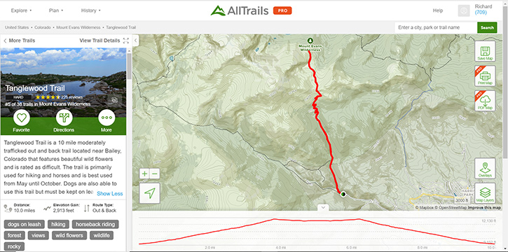
I found exactly what I was looking for and the trail is called Tanglewood Trail and it is just northwest of Bailey, Colorado.

You can really see the details of the hike now. The plan view shows the route, the trail head and the destination. Right below the map view is a profile of the trail and the nice things is you can drag your cursor along the profile and see exactly where  that is on the map.
On the left side of the screen you will notice a general description of the trail. In the photo you will see how other hikers have rated the trail and difficulty. This one is rated as HARD, but I’m okay with that. A little farther down you will see the trail length and elevation gain and whether it is a loop trail or out and back.
I always want to take a look at what other hikers have said or experienced before me on the trail, and here are a few of their comments and how it impressed me or caused me to look at a different trail.
The first review isn’t the greatest, but it’s nice to know they used the word “awesome” in their description.
The second review is more descriptive and I love that there are chipmunks in the area but one thing I don’t like to see is large areas of dead trees due to the beetles.
The third review really caught my attention with the hiker saying they would definitely hike this trail again. She describes some of the trail, and things along it and how there are some great views to be seen.
So, the next thing I went to are the hundreds of photos that were taken on the trail and you can see for yourself that there are definitely some great views on this trail.

This was enough to sell me on the trail I wanted to hike this weekend.
AllTrails Pro
AllTrails Pro has some really nice features for only $29.99 per year and I believe you can pay monthly for $4.99 which is not much in my book for all the benefits I get from it.
You will be able to download maps, print them, download them to your smartphone and much more. One nice feature you will get is being able to download the route to your GPS navigator or your Emergency Satellite Messenger.

AllTrails has a list of 30 or more formats you can download, depending on your device.
Let me quickly show you a few pictures from the AllTrails App.
AllTrails App

Here is an image of the Tanglewood Trail information. You can see it has the same information as the PC image above but you can’t see the map and profile yet which show up below the trail description.

Another thing I really like with the app is you can download any map layer you want to your smartphone before you leave for the trail so you will have access to the information, even if you cell service limits the amount of data you can download in the mountains.

My Final Thoughts on AllTrails Colorado
I have used AllTrails for many years, even when I lived in Oklahoma and only took occasional trips to Colorado and New Mexico but I have recently moved to Colorado and I use AllTrails several times each week as I look for new trails and plan my next adventure. I highly recommend you try AllTrails out. You will love how much information is there and how easy it is to use.
Please leave a Comment below or leave me an Email if you have a more in depth question.
If you would like some more information on Emergency Satellite Messengers, some with navigation, you can find that at my Emergency Radio Reviews page.
Check out these Top 11 Satellite Messengers of 2023 in this YouTube video below.
Return to Home Page

- Hardcover Book
- Mizielinska, Aleksandra (Author)
- English (Publication Language)
- 112 Pages - 10/08/2013 (Publication Date) - Big Picture Press (Publisher)

- The Rand McNally Large Scale Road Atlas 2025 is ideal for keeping in your car. This road atlas provides handy views of North American roadways, along with inset maps of more than 375 North American cities.
- Deluxe road atlas is 35% bigger than the standard Rand McNally atlas.
- Updated 2025 edition features large print maps of every U.S. state and Canadian province, plus an overview map of Mexico.
- Detailed inset maps of more than 375 North American cities and 28 national parks.
- Mileage and driving times map show distance and approximate driving times between hundreds of cities.
- Rand McNally (Author)

- Keep the Rand McNally Midsize Easy to Read Deluxe Road Atlas 2025 in your car or glove box. This road atlas provides handy views of North American roadways, along with inset maps of more than 50 North American cities.
- Deluxe road atlas is 35% bigger than the standard Rand McNally atlas.
- Updated 2025 edition features large print maps of every U.S. state and Candian province, plus an overview map of Mexico.
- Detailed inset maps of more than 50 North American cities.
- Mileage and driving times map show distance and approximate driving times between hundreds of cities.
- Rand McNally (Author)

- Teach geography using the Rand McNally United States Interstate Fold Map. This folded interstate map is complete with clearly indicated cartography and points of interest.
- Folded map features all Interstate and U.S. highways.
- Clear, easy-to-read cartography.
- Clearly indicated cities, points of interest, airports, boundaries and more.
- Measures 9-1/2" x 4".
- Rand McNally (Author)
![National Geographic Road Atlas 2025: Adventure Edition [United States, Canada, Mexico]](https://m.media-amazon.com/images/I/51g+DvKGgYL._SL160_.jpg)
- Folded Dimensions: 11 x 15 in
- Recommended Use: hiking & camping
- National Geographic Maps (Author)
- English (Publication Language)
- 144 Pages - 06/10/2024 (Publication Date) - National Geographic Maps (Publisher)
This product was presentation was made with AAWP plugin.
![]()
AllTrails
Free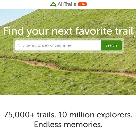
Pros
- Easy Website to Get Around In
- Great AllTrails App
- Thousands of Trails
- Helpful Trail Information
- Up to Date Trail Reviews
Cons
- AllTrails Pro $4.99/mo (Not a Bad Thing)
You’re right for suggesting to download map layers before setting on the trail as you can lose phone signal in the remote areas. That is a very smart thing to do. I bet the maps are accurate and can guide hikers offline. But I’d like to ask, are there any possibilities of uninterrupted internet signal via direct satellite connection even if you go deep up in the mountain trails in Colorado? I wonder about this because I saw on Youtube soldiers still communicate with the military base even if they’re fighting in a mountain summit in Afghanistan. What do they use to connect and communicate?
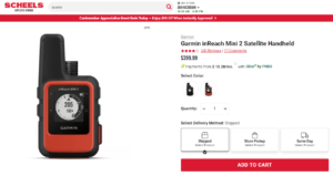
I would only rely on my smartphone and AllTrails app when I was pretty confident I would stay in cell coverage or at least have enough of a signal to see my location on the map. If you’re going very deep into the mountains or anywhere you know that the cell signal will be weak or non-existent, then I would go with the Garmin inReach Explorer+ as it has the emergency SOS distress call plus, navigation, plus 2-way messaging. See it here:
https://hikingemergencybeacon.com/garmin-inreach-explorer-review/
Explorers and military personnel use satellite phones and other technology that I’m not aware of but they are primarily using satellites.
Rick
Boy, do I know some hiking “nuts” that will love this app! Here’s a question I think I know the answer to, but just want to check. Does AllTrails have trail maps for every state? I’m guessing it does. Now I look again and see that you say the app shows trails all over the world. Therefore, I’m guessing that Alaska would show up on there, too. Guess I’d better go look at this app!
The price is certainly reasonable for someone that hikes a lot. I will send this information to a couple of friends right away. Thanks for posting!
Hey Fran. Alaska, Canada and Hawaii all have trails on AllTrails. So does South America, Africa, Europe, Asia, Australia, and the list goes on. The great thing is that it’s the users of the website and app that make it so powerful.
Rick
Now I know what to get if I ever want to go hiking in Colorado. I think it’s great that they are open to having users input information to make their app better. And to think, AllTrails isn’t just limited to Colorado! I can definitely see how it would keep you busy for years. Even knowing about the chipmunks and beetles is awesome. It sounds like the developers are truly more interested in the awe and happiness of the users than money. I’m wondering what its shortcomings are; it just seems too good to be true. I really want to try this now. Thanks for sharing!
I have been using AllTrails for about two years now and I know there are other websites out there like theirs but they have a site that is really easy to use and there are thousands of hikers out there that are taking photos and providing extremely helpful feedback. They have a lot of information you can access for free but I have chosen to pay for the PRO, which isn’t much money for the benefits I get from it. You should try it out and let me know what you think.
This information is very valuable, and I will share it with my cousin, who loves to hike. In fact, I think every person who loves to hike should like at this website, as it is filled with a ton of information (is it possible to say, “too much” in the most positive, meaningful way?). I had no idea that trails were mapped out in such detail. This is great for everyone who lives in Colorado, but is there an “AllTrails” for other States, as well? I guess that would be “too much” of a good thing!
Great website template, too. I might change my website over to this one, as it is nicely detailed and easy to maneuver through. I appreciate the product reviews, including accessories such as batteries and chargers. If you’re going to hike, you have to do it right, and being properly prepared is extremely important in the event of an emergency. Good job in covering all the bases.
Hi Ron. Thank you for the kind words about the website.
I guess I am being a little misleading when I say AllTrails Colorado. I do not intend to mislead anyone. AllTrails has trail information pretty much in every country in the world. They definitely have trails in Canada, Alaska, Hawaii, South America, Africa, Europe, Asia and Australia, but I’m not sure they cover the Antarctica.
Rick
I, too, have been using AllTrails for some time to locate hikes in my own area of Southwest British Columbia. Many hike to chose from.
I like all the features you talk about especially GPS. You always know where you are and, if you have a satellite phone and get in trouble you can call for help and give them an exact elevation.
Did you know that AllTrails is currently offering a 50% discount today(Sept. 19)? You can get a whole year for less than $15. Not sure how long that’s going to last but it’s a heck of a deal.
I’d like to do a trip to Colorado sometime next year. This hike looks very appealing.
Hiking can be a lot of work but, in my mind, it’s worth the effort to see those magnificent views. Using AllTrails makes it that much better.
Sorry, I don’t have any questions. I just had to let you know how much I like the app,
Wayne
Hi Wayne. I have no problem with not having questions. It’s just great to hear that someone else loves using AllTrails also.
I’m going to have to see if I can take advantage of the AllTrails discount and save some money. Thank you for the heads up.
Rick