MapShare with Garmin inReach Mini 2

Using MapShare with Garmin inReach Mini 2 is an easy way for your family and friends to follow your outdoor adventure and will give them the peace of mind that you’re okay and will show them exactly where you are at all times, as long as you have tracking turned on.

Garmin inReach Mini 2

MapShare Setup Before Hitting the Trail

Go into your Garmin User Page and click on the [Social] tab at the top right of the page.

Garmin User Page

Take some time to decide how you want to share your location with Family and Friends. You can choose to share it publicly on FaceBook and Twitter or you can share it privately with a password via an email.

MapShare Options

Once you take care of your MapShare settings, it’s time to head out on your adventure.

Garmin inReach Mini 2

What You Need to do on Your Adventure

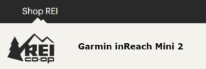
First, you have to turn on tracking, if you don’t have auto tracking on. I recommend you turn on Auto Tracking if you’re going to use MapShare. The reason I say this is you may forget to start tracking if it’s not on auto and then no one would be able to see your location.

Here are some screenshot of the Garmin inReach Mini 2 to show you where you need to go in the menu settings to turn AutoTrack on.

Garmin inReach Mini 2 AutoTrack Settings

Next, go on your adventure, then when you’re finished you can turn Tracking or AutoTrack back off. I recommend turning AutoTrack off when your not on your outdoor adventure or it will keep tracking you while you’re at home.

How Your Family & Friends can See You

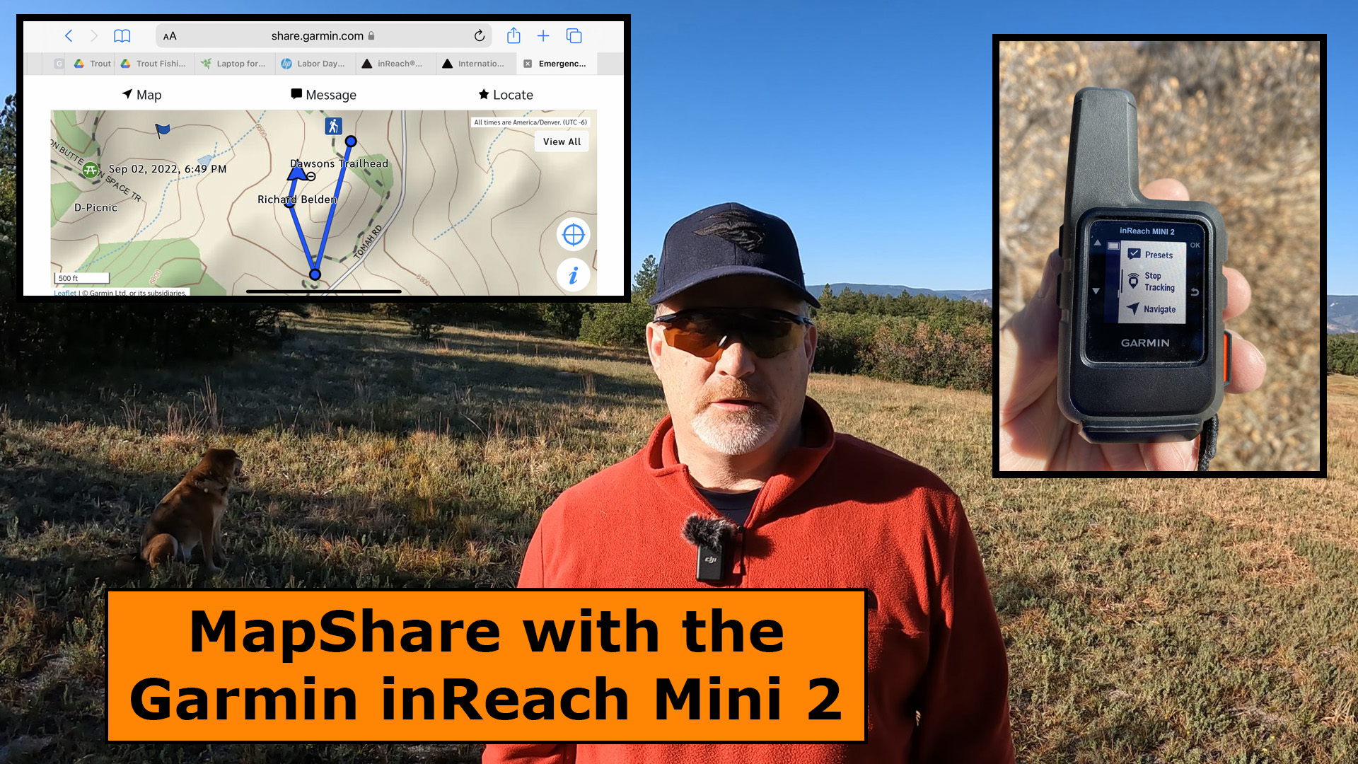
I chose to send the MapShare information to my family by email, rather then sending it to FaceBook and Twitter. The people you send MapShare to will receive an email like the one below.

Garmin MapShare Email

Click on the link in the email and you will be re-directed to the Garmin site where it will ask for a password if you set it up that way.

Garmin Explore MapShare Login

After you enter the password, the Garmin Explore map page will be displayed, and you should see something like this below.

Garmin MapShare Map and Tracks

That’s all there is to it, however, I strongly recommend you test this out close to home before heading out on your adventure to make sure everything is set up correctly.

Final Thoughts

MapShare is an extremely powerful tool and one that your family and friends will really appreciate. Check out this short YouTube video below of my field test of MapShare.

Sale
Garmin inReach Mini 2, Lightweight and Compact Satellite Communicator, Hiking Handheld, Orange - 010-02602-00
  • Compact, lightweight satellite communicator enables two-way messaging and interactive SOS globally (Active satellite subscription required. Some jurisdictions regulate or prohibit the use of satellite communication devices.).Special Feature:Bluetooth.Water Resistant: Yes
  • Navigate back to where you started by using TracBack routing
  • Share your location with loved ones back home at any time (active satellite subscription required) by using your MapShare page or with your coordinates embedded in your messages
  • Get accurate heading information using the digital compass — even when you’re not moving
  • Sync with the Garmin Explore app and website on your compatible smartphone for trip planning and topographical mapping, and create waypoints, courses, activities and collections you can sync to your device
  • Pair with Garmin devices, such as wearables and handhelds, and use them to send and receive messages and trigger an SOS (active satellite subscription required)

This product was presentation was made with AAWP plugin.

Sale
Garmin 010-01735-10 inReach Explorer+, Handheld Satellite Communicator with Topo Maps and GPS Navigation
  • 100 percent global Iridium satellite coverage enables two way text messaging from anywhere (satellite subscription required)
  • Trigger an interactive SOS to the 24/7 search and rescue monitoring center
  • Track and share your location with family and friends. Water rating : IPX7. Battery : Rechargeable internal lithium ion
  • Pair with mobile devices using the free earthmate app for access to downloadable maps, U.S. NOAA charts, color aerial imagery and more
  • In reach explorerplus device adds preloaded Delorme topo maps with onscreen GPS routing plus built in digital compass, barometric altimeter and accelerometer

This product was presentation was made with AAWP plugin.

Sale
Garmin GPSMAP 66i, GPS Handheld and Satellite Communicator, Featuring TopoActive mapping and inReach Technology, Multi
  • Large 3 inch Sunlight-readable color display for easy viewing
  • Trigger an interactive SOS to the geos 24/7 search and rescue monitoring center, two-way messaging via the 100% Global Iridium satellite network (satellite subscription required)
  • Preloaded Garmin TOPO mapping with direct-to-device Birdseye satellite imagery downloads (no annual subscription), includes multiple global navigation satellite systems (GNSS) support and navigation sensors
  • Cellular connectivity lets you access active weather forecasts and geocaching live
  • Compatible with the Garmin explore website and app to help you manage waypoints, routes, activities and collections, use tracks and review trip data from the field
  • Internal, rechargeable lithium battery provides up to 35 hours of battery life in 10-minute tracking mode and 1-minute tracking mode (display off), 200 hours in Expedition mode with 30-minute tracking

This product was presentation was made with AAWP plugin.

Return to Home Page

2 thoughts on “MapShare with Garmin inReach Mini 2”

  1. My son passed away on backside of Peak 6, Breckinridge, Colorado on Aug. 27, 2022. Without his Garmin we would not have been able to locate him. Thank you Garmin for allowing us to locate our son. It meant everything to us and it aided in search and rescue being able to recover him. With gratitude, Sharon Bolster, mother of Zach Bolster, U. S. Navy DEVGRU

    Reply

Leave a Comment